Richland-Wilkin Joint Powers Authority
Original Publication Date: February 6th, 2014
Wahpeton Daily News
Republished with permission from:
Cash Aaland, director Mndak Upstream Coalition
Two weeks ago the Mndak Upstream Coalition detailed an alternative to Fargo’s diversion plan that would put Fargo first and deliver the same level of protection for the F-M Metro without impacting upstream communities.
If the southern inlet to the F-M diversion is moved three miles north, all impacts to Richland and Wilkin counties would be eliminated. Comstock would not be flooded, Wolverton, Minn., would not be flooded and there would be no need for taxpayers to spend $70 million on a new private golf course and country club for Oxbow. This alternative provides these benefits, even if no upstream retention is implemented.
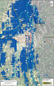
[Click Image for Large View]
A map of the staging area without any upstream retention can be viewed upper right.
View comparison via this link: http://fmdam.org/preserve-flood-plain/
The only difference between this alternative and Fargo’s current plan is the water is staged in the flood plain where it already floods. Fargo’s plan destroys this flood plain, eliminates all the natural storage area and backs the water up onto communities such as Comstock and Wolverton that do not now flood.
Additionally, taxpayers would save more than $200 million as:
1) the Wild Rice River dam would be unnecessary;
2) spending $70 million tax dollars on a new private golf course, country club and
ring dike for Oxbow would be unnecessary. Oxbow is currently protected to a level
of 918 feet according to documents released by the state water commissioner. If
the inlet is moved north of the Wild Rice/Red River confluence during a near
500-year flood in Fargo – 42.5 feet – the water level in Oxbow would only be 917.56.
Again, this is without any upstream retention.
How does this work?
The “Fargo First” alternative takes advantage of the natural flood plain, storing water in the low area that always floods and should not be developed. This area is depicted in blue on the map that can be viewed at FMDam.org at the above listed link. This natural low area starts at the confluence and extends south for three miles. Fargo’s plan eliminates this natural flood plain, storing the water instead over a huge area centering on Comstock and the Bakke subdivision, two areas that have never flooded.
There are almost no impacts caused by this “Fargo First” plan, according to the criteria set out by the Army Corps and Fargo’s Diversion Authority. This is because the area where the water is staged, low-lying flood plain, would be inundated during a 42.5 foot Fargo flood without the project.
In summary, the Fargo First alternative costs less, impacts fewer people, removes impacts from Richland and Wilkin counties and eliminates the need to ring dike Comstock, Wolverton and Oxbow. This alternative provides the exact same level of protection to the F-M Metro while preserving the flood plain. Basin-wide protection by upstream retention could then be built over time, after the danger of a catastrophic flood to the F-M Metro is removed by the proposed “Fargo First” alternative.
This plan puts Fargo First, ahead of the special interests, land developers and Oxbow’s private country club owners. What’s it going to be: Protection for Fargo citizens, or a poorly conceived overpriced development plan that favors Fargo special interests at the expense of everyone else?
Views: 80
