
Continued from:
Part 1 – Exposing the FMDA and USACE
Part 2 – Exposing the FMDA and USACE
Part 3 – Exposing the FMDA and USACE
Part 4 – Exposing the FMDA and USACE
Part 5 – Exposing the FMDA and USACE
If Fargo-Moorhead were a house with a leaky roof and Fargo had 100 (5 gallon) pails and Moorhead had 100 (1 gallon) pails and those pails represented natural flood plain to catch the water, Fargo is trying to steal Moorhead’s pails because Fargo did not protect their pails and Moorhead reduced their need for pails by addressing their portion of the leaky roof with permanent features.
Sadly, FMDA (Fargo Moorhead Diversion Authority) proponents are trying sell the idea that a new roof covering the entire property is needed, rather that repairing the existing roof to prevent problems.
There is a level of insanity that comes with FMDA proponents. It is one minded, imperialism that argues development of a low laying flood plain that has flooded during every significant flood – rather than adhering to responsible building practices and developing higher ground that is more defensible during every type of flood event.
| Excerpt from USACE Appendix P Fargo-Moorhead FEIS | |
|---|---|
| According to the USACE: | “…further floodplain development within this total Metro Area would appear now to make most sense to be in the eastern portion of Moorhead rather than within Fargo…” (read more…) |
FMDA proponents have repeatedly claimed the proposed project had evolved from the best science and engineering minds.
Is this really the case?
According to the most recent FEMA FIS (Flood Insurance Studies) conducted in Richland County, ND (View Richland Study) and Cass County, ND (View Cass Study) – Houston Engineering played an essential role in the hydrologic and hydraulic analysis. Houston Engineering is specifically named in the forward of both FEMA studies.
Another interesting notation located in the BIBLIOGRAPHY AND REFERENCES section of the Cass County FEMA FIS denotes Houston Engineering citing a Technical Support Data Notebook for City of Fargo, North Dakota Flood Insurance Study allegedly drafted by Houston Engineering Inc in 2007.
According to Google the Wild Rice River in North Dakota is approximately 251 miles long from the Wild Rice and Red River confluence to the Wild Rice headwaters.
Had Houston Engineering been more thorough in their analysis of the Wild Rice River, perhaps more than 48.82 miles (19.4 percent) would have been included in the FEMA FIS.
Ironically, the Wild Rice River gauge at Abercrombie, ND does not appear in the FEMA FIS for Richland County, ND.
During the 2009 flood, there were several references to the Wild Rice River Gauge at Abercrombie, ND and the Red River Gauge at Hickson, ND being used as “key” indicators of the potential flood bearing down on the Fargo-Moorhead area.
In the years following the 2009 flood, these two river gauges would be used in various ways as a supportive argument for the proposed Fargo Dam and FM Diversion project.
Chad Engels, Moore Engineering, went even further by peddling a theory of the combined flows of the river gauges to the North Dakota Legislative Management Water-Related Topics Overview Committee highlighting the combined 2009 river flows from the Hickson, ND and Abercrombie, ND gauges being 38,700 cfs – yet the Red River Gauge at Fargo, ND represented only 29,500 cfs.
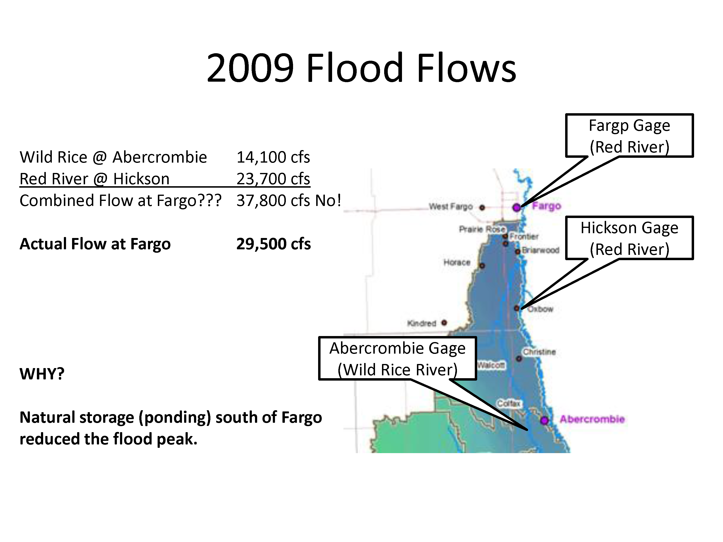
In this illustration, Chad Engels, Moore Engineering, suggests that “natural storage” south of Fargo reduced the peak cfs in Fargo by nearly 8,300 cfs.
Seems to fit rather nicely into the FMDA narrative that flood-mageddon is right around the corner.
Even more comical is the term “natural storage”, which is just another word for “distributed retention”, a concept that proponents emphatically claim will not work.
It does beg the question why city and county officials are not restricting encroachment and destruction of the very natural flood plain that provided “distributed retention” and attenuated the 2009 flood?
Here is the rub…
The FEMA FIS for Richland County, ND ended over 6-8 river miles downstream of the Wild River Gauge at Abercrombie, ND and nearly 80.6 percent of the Wild Rice River was completely ignored and not included in the FEMA FIS for Richland County.
Chad Engels, Moore Engineering, did not include any study data detailing the amount of water migrating back to the Red River via overland flooding after it had been quantified at the Wild Rice Gauge, Abercrombie, ND.
Residents in Richland County witnessed first hand that when the Red River and Wild Rice Rivers reach a certain flood stage, discerning one river from the other is nearly impossible.
It seems pretty reckless to suggest you can combine flows of two river gauges nearly 18 river miles apart and willfully downplay and ignore the amount of water that migrated back into the Red River upstream of Hickson, ND to be quantified again as an unprecedented historical 300+ year flood level and somehow, magically, in less than 32 river miles the flood event is reduced to an “alleged” 50 year flood event?
How will the newly appointed governors task force(s) appointees resolve inconsistencies and blatantly corrupted data as they work towards a cooperative solution for the region?
Maybe the “experts”… “are not…”
More to come in Part 7.
Views: 633