This will be a multi-part series due to the complex nature of the content.
A government entity, whether it is a city, county or state, owes a duty of honesty and transparency to the population they govern. This extends to the various adhoc committees, task forces and boards created to carry out the actions and agendas on behalf of local government being represented.
The FMDA (Fargo Dam and FM Diversion Authority), which has gone through several name changes since inception, attempts to operate under the cloak of protection from what they refer to as “stakeholder entities”.
Discovery documents provided after oral arguments in U.S. District Court before presiding Judge John A. Tunheim on July 18, 2017 illustrates a pattern of deception by the FMDA and USACE that imperils property owners – which contradicts the public relations narrative being delivered by the FDMA.
The whole FMDA project is centered around propaganda that the FM area is facing a water apocalypse to position property owners and FEMA on a collision course, yet incoherently allows destruction of natural flood plain that protects Fargo’s residents under false pretense.
On September 30, 2016 the FMDA generated a FM Diversion CLOMR Support Document which is a Conditional Letter of Map Revision requesting that FEMA raise the 100 year BFE (base flood elevation).
This is an extremely dangerous gamble. These are non-elected FMDA members, requesting a change in how FEMA views your property. Mandatory NFIP flood insurance requirements that went into effect for about 2,300 property owners in Jan 2015 have FMDA and USACE to thank for the added expense.
If FEMA raises the 100 year BFE and requires more properties to carry mandatory flood insurance, there is no guarantee that FEMA will remove that requirement when permanent internal flood protections are completed or if the overall Fargo Dam and FM Diversion is built because a new and greater risk exists as a result.
Visuals are the key to great propaganda and the FMDA has paid MILLIONS for the goal oriented propaganda they are using.
One misleading visual central to the CLOMR request is this image.
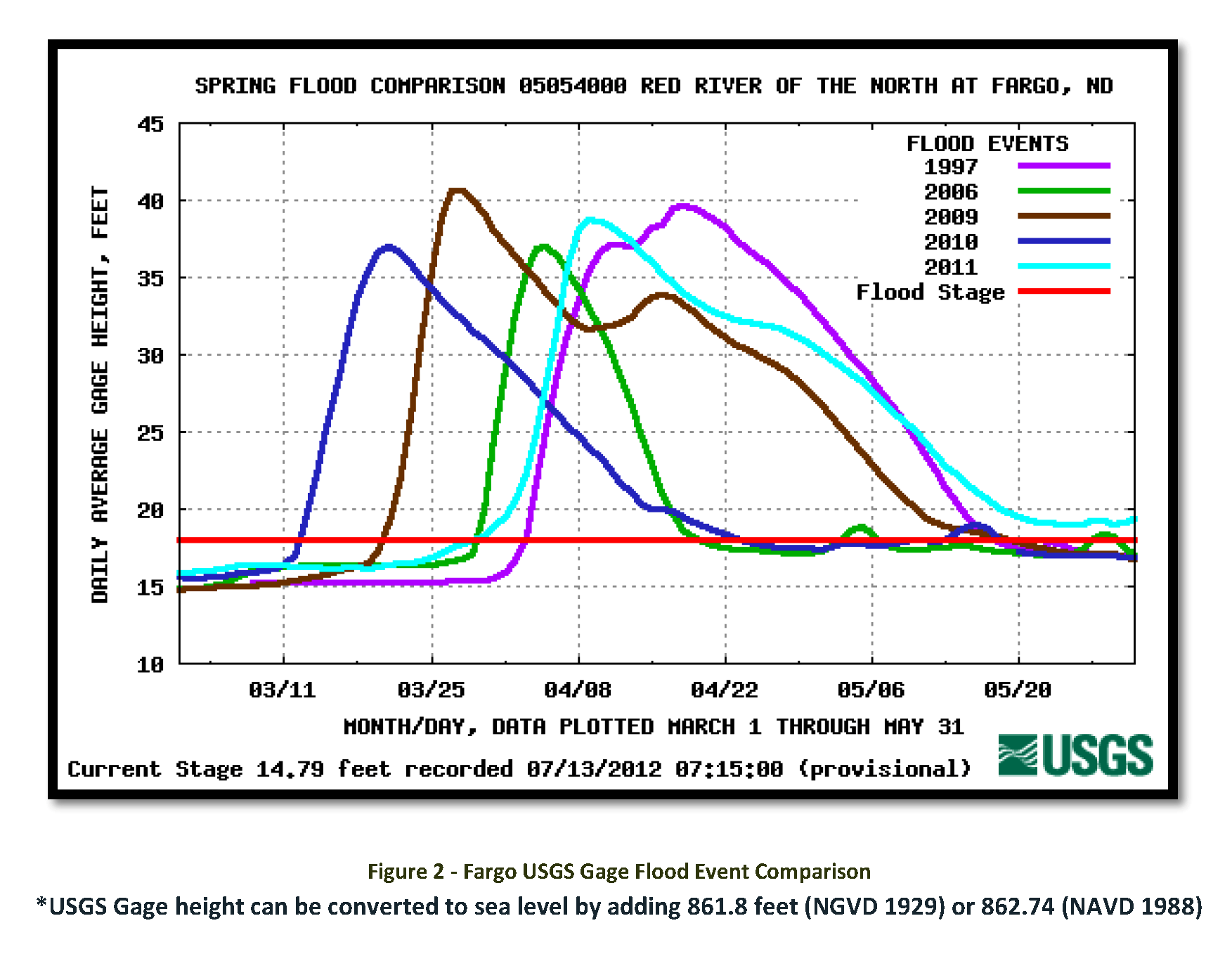
Why is it misleading?
Because it uses the lowest flood threshold of 18 feet, which is 20 feet lower than the 38 foot threshold set for sandbagging, to convey a false risk to the Fargo Moorhead area in comparison to record flood events. Nothing happens at 18 feet, aside from water leaving the river channel along the lowest section of riverbank of Elm Street, which is built on the river bank 12 feet below major flood stage.
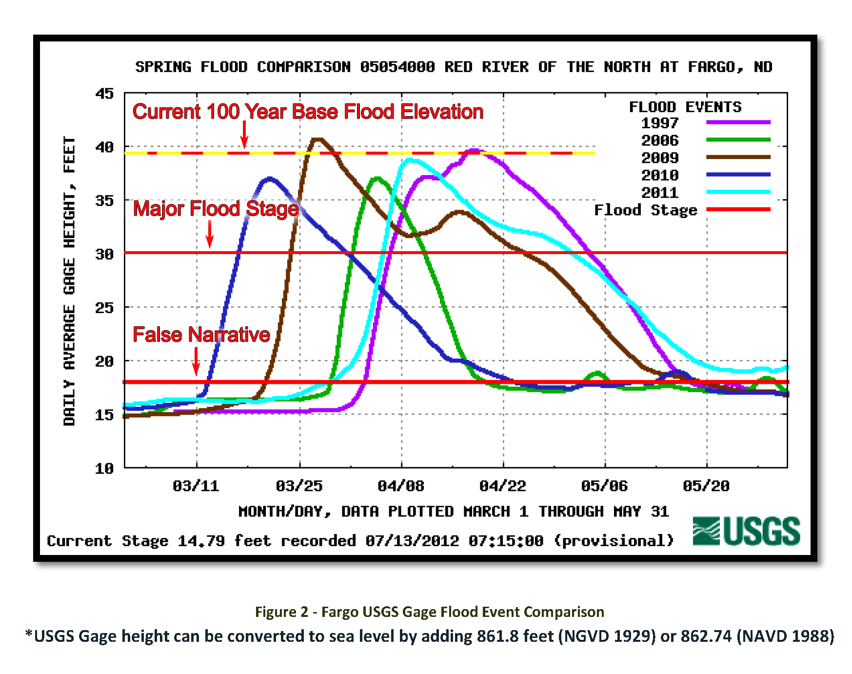
Here is a more accurate representation of flood stages in the Fargo – Moorhead area.
On April 1, 1979, President Jimmy Carter signed the executive order that created what we refer to as the Federal Emergency Management Agency (FEMA). However, the current version of FEMA can trace its origins back to a Congressional Act of 1803, wherein, the first piece of disaster legislation, provided assistance to Portsmouth, New Hampshire which experienced an extensive fire in 1802.
In January 1980, FEMA released a Flood Insurance Study for Cass County, ND (read more) which indicates a 100 year flood event in Fargo, ND at 29,000 cfs (cubic feet per second) discharge (located on page 5 -or- physical page 8). FEMA revised that estimate rating in September 2002 to 29,300 cfs discharge and affirmed 29,300 cfs discharge as a 100 year event in the Flood Insurance Study for Cass County, ND released July 27, 2012.
Take note of that discharge because it is an extremely important number. The “cfs” discharge is used to determine the potential for flooding based on your proximity to a floodway or adjacent flood plain.
USGS records indicate the 2009 flood exceeded all previous 100 year (1 percent) base flood elevations at the Red River Gage, topping 40.84 feet at 29,500 cfs.
However, the CLOMR document prepared for the FMDA by CH2M Hill (agents being paid by the FMDA) disregards FEMA (the entity that determines flood insurance requirement) and attempts to downgrade previous floods to embellish future flood forecasts based on theoretical assumptions and junk science, which in turn increases the likely-hood of you paying for NFIP flood insurance or driving NFIP premiums higher.
Is this an unscrupulous attempt by the FMDA to raise the 100 year base flood elevation to conceal the actual impacts of the proposed project to cheat property owners and reduce the amount of financial mitigation to be paid to areas outside the project footprint?
FEMA, influenced by the USACE, already increased the downstream 100 year base flood elevation at Grand Forks, ND on December 17, 2010 which conceals 14.4 inches (read more) of impacts as a result of the FMDA project.
More to come in Part 2: EOE Study – The Invalid Assumptions
Views: 842