In a February 11, 2017 Forum op-ed piece, meteorologist John Wheeler came very close to putting the sublime into words but fell painfully short with FMDA (Fargo Moorhead Diversion Authority) rhetoric in the 1897 flood comparison.
Let me preface this by stating that John Wheeler is an excellent meteorologist. He appears engaging and committed to his career field and serves our region with a measure of professionalism while maintaining relate-ability to the average person.
Here is John Wheeler’s original article:
| Weather Talk: Flood mitigation efforts make floods crest higher By John Wheeler – WDAY meteorologist on Feb 11, 2017Severe river floods in 2011, 2010, 2009, 2005, 2001 and 1997 all changed Fargo Moorhead in one way or another. Home buyouts, dike construction, the Sheyenne Diversion and the grander Fargo-Moorhead diversion have been built (or are planned) to keep the water within the river channel or on farmland outside of the city. But all of this displacement of water has the effect of making the floods crest higher. It is coming up on 120 years since the great flood of 1897, in which a 1997-like snowpack melted very quickly and was accompanied by heavy rain. The river in Fargo crested April 15, 1897, at 40.1 feet, which is within a few inches of the record crest of 40.84 in 2009. But for the 1897 flood, there were no levees. Not one single sandbag was laid. The river rose, flooded everything except the highest ground, and receded. Had the 1897 flood crest been hemmed in by flood mitigation like contemporary floods, the crest would have been significantly higher than any of the recent floods. |
With the exception of the 1897 flood comparison, Wheeler is generally spot on with his assessment.
The most profound statement being:
| “the grander Fargo-Moorhead diversion have been built (or are planned) to keep the water within the river channel or on farmland outside of the city. But all of this displacement of water has the effect of making the floods crest higher.” |
Water displacement is the leading cause for Fargo’s flooding issues and mandatory FEMA flood insurance requirements.
It is also one of the central tenets in FEMA’s warning letter sent to Fargo Diversion Authority chairman Darrell Vanyo stating specifically that floodways and any adjacent floodplain area must be kept free of encroachment.
Here is a prime example of why… (click video)
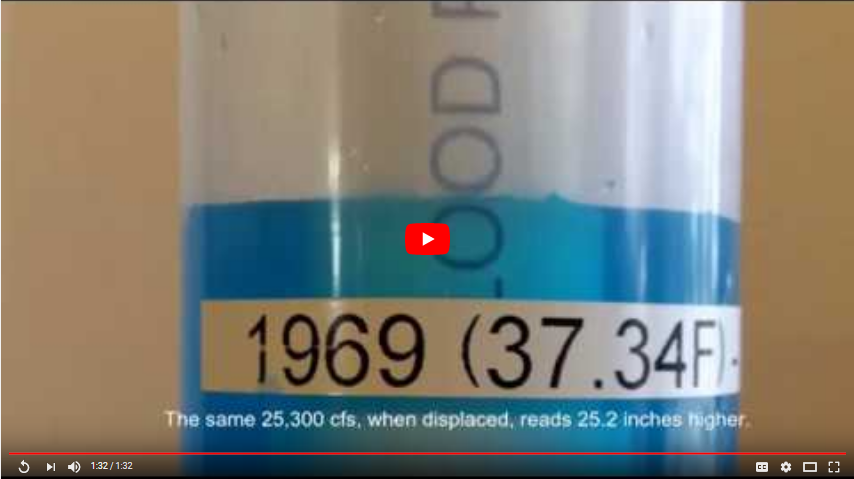
John Wheeler understands the concept of water displacement and its net effect on the Red River gage at Fargo.
However, Wheeler attempts to apply the 1897 flood to the modern day region and Fargo, ND ~ which is extremely misleading.
The region in, around and upstream of Fargo, ND was largely undeveloped in 1897. In fact, North Dakota (as a state) was barely 8 years old.
The current grid-work of township, county, state and federal roadways did not exist as they do in present day. Also, conspicuously missing in 1897 would be the multitude of dams, bridges and culverts that “slow down” the migration of water towards Fargo.
The nature and impact of any flood is the proximity to population and how it is controlled.
Yes, the 1897 flood was impressive because there was essentially nothing in the path of the water as it headed towards Fargo, ND.
In short, if the 1897 flood were to occur in present day, it would not be the magnificent historical flood example as depicted in history books. Largely, as result of the existing infrastructure and flood controls in place.
If the pro-diversion ilk truly believes that distributed retention doesn’t work, then remove all dams upstream of Fargo and increase the sizing of all culverts to prevent any water from being held back and let the water decide where it should be.
Views: 1034
the best argument for retention i have heard.