Richland-Wilkin Joint Powers Authority
Original Publication Date:
April 3rd, 2014
Wahpeton Daily News
Republished with permission from:
JPA Editorial Team
Location, location, location, is the key to selling real estate and the key to understanding the economics of the Fargo-Moorhead Diversion dam and levee.
The F-M Diversion plan boils down to two desired goals. One is flood protection for the existing city of Fargo, and the second is protection for the currently undeveloped flood plain.
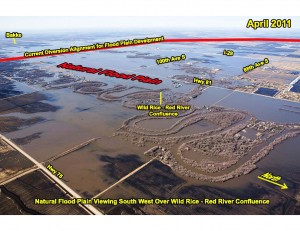
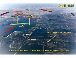
There’s a good reason it’s currently undeveloped … it’s a natural floodplain. It’s the area where the water naturally collects as it’s been doing since our river system was formed by Mother Nature.
Fargo has a “Comprehensive Flood Plan” to achieve permanent flood protection for its internal locations. The plan includes dikes, levees and buyouts that will give the city the needed protection. It provides FEMA certified flood protection that will remove much of the requirements for flood insurance.
Fargo leaders say it will cost $247 million to fully implement city leaders’ goal of 42.5 foot protection.
See more at: www.bakkentoday.com and Fargo – Long Term Flood Protection
The location of the F-M Diversion dam and levee determines how much of the natural flood plain is “protected” for development. The farther south the dam and levee are located, the larger the portion of Cass County that is protected for subsidized development. “The larger the protected area the better the plan is,” as the F-M Diversion documents note. In other words, Fargo wants to develop the natural floodplain, so someone else has to store the water.
The sticking point is, of course, the location of the dam and levee, because location determines who is protected and who is to be flooded. This project will provide protection for those who have built in the flood plain and legitimizes the decision by the city and the county to permit structures like Davies High School.  It eliminates the required FEMA flood plain development regulations for new development, which will cost the special interests “$55,000-$70,000” per lot, according to the Army Corps Environmental Impact Statement. The Environmental Impact Statement goes on to say, “These types of land use would use approximately 42 percent of the projects developable land area.”
This desire to relocate the flood plain with the current Diversion project will flood those who are not flooded naturally and is to be funded by our North Dakota tax dollars which become, in fact, a subsidy for the developers. The larger the area protected, the more money for the developers, contractors and profiteers.
Location, location, location, is the key to understanding the reason for this project.
Views: 291