Part 4 of 7 addressing Ken Pawluk’s letter to the Fargo Forum.
In Ken Pawluk’s July 26, 2015 rant submitted to the Fargo Forum, he takes exception with Wilkin County commissioner Lyle Hovland’s July 7, 2015 letter in response to Clay Dietrich’s (FM Homebuilders Association) June 25, 2015 letter to the editor.
Mr. Pawluk, didn’t miss a chance to beat the dead horse of comparing Grand Forks and Minot to some flood of mythical proportion waiting around the corner for Fargo residents. Insulting as that may be to any person of reasonable intelligence, the marginalization of what Grand Forks and Minot experienced as call to action for Fargo’s development agenda under the guise of flood control is detestable.
Here are links to all three letters for your consideration:
2015-06-25 Clay Dietrich Letter
For more on the Home Builders Associations role: (Read this Article)
| Ken Pawluk July 26, 2015 letter to Fargo Forum Does Commissioner Lyle Hovland also think that Grand Forks was at fault for the flood disaster that devastated the city in 1997? Or similarly, the flooding in Minot in 2011? To somehow claim victory by preventing others from achieving long-term flood protection is disappointingly shallow. |
Sorry commissioner Pawluk, but your allegations don’t hold water, and that’s pretty “dam” sad.
Both Grand Forks and Minot flood protection measures were over-topped and your use of those entities as example is “shallow”.
Which is why Fargo’s ONLY FOCUS should be on completing and shoring up internal flood protection to safeguard the city that exists. That $198 million you and your ilk have spent on a dam and diversion project that has not turned a shovel of dirt could have gone a LONG WAY toward completing Fargo’s internal flood protection.
So who is “REALLY” preventing Fargo achieving flood protection…?
Also, the propensity of comparing Grand Forks and Minot to some future hypothetical flood potential at Fargo is imbecilic.
Quick facts:
Drainage
Grand Forks has 30,100 square miles of upstream drainage area
which includes 20 significant rivers, streams, creek and coulees.↳ whereas Fargo has 6,800 square miles of upstream drainage area
which includes 6 significant rivers, streams, creek and coulees.Minot has 10,600 square miles of upstream drainage area of which
3,900 square miles listed that contributes to flash flooding.↳ whereas Fargo has 6,800 square miles of upstream drainage area
and ZERO square miles listed that contributes to flash flooding.CFS ( cubic feet of streamflow )
Grand Forks’ greatest flood had 52,000 cfs more
flow than the previous record set in 1897
and 49,500 cfs more flow than 2011.Minot’s greatest flood had 14,900 cfs more
flow than the previous record set in 1904.
Fargo’s greatest flood had 1,500 cfs more
flow than the previous record set in 1997.
Flooding is all about drainage and topography…, and the overt flatness in and around the FM area (roughly 1 ft of elevation per mile) allows water to spread out over much greater areas requiring significantly greater capacity cfs flows to reach a higher gage reading.
What Mr. Pawluk and his ilk appear incapable of understanding is that construction of any form of flood protection does not remove the flood risk or guarantee a loss will never occur. (i.e. Grand Forks and Minot) Construction of flood protection merely reduces the statistical probability that flooding might occur within the design criteria.
The greater Fargo Moorhead area has had ample time since 1997 and 2009 to complete internal flood protection measures to protect the property owners in the metro area.
West Fargo addressed their flooding issues long ago.
Moorhead and the state of MN moved swiftly post 2009 to protect their constituents.
Yet, Fargo dragged it’s feet until 2014 to lift one finger or spend one dollar for flood control in front of city hall.
The obsessive incompetent nature of the Fargo Diversion Authority has clouded rationale thinking, with a contrived threat of FEMA flood insurance, towards viable flood protection for the city that exists, in pursuit of Fargo expanding its borders with flood plain encroachment that should never exist.
Commissioner Pawluk, the closing statement in your letter “…I do not welcome is short-sighted commentary or those looking to blame my constituents for the flooding they face…” is a blatant example of your failed leadership and that of your ilk.
It is unfortunate that the very agencies that should be working in tension to each other are expected to acquiesce or be cast out, much like what happened with the Buffalo Red River Watershed District and West Fargo.
Cass county, Fargo and the Diversion Authority are only interested in “yes-men” who are willing to “parrot” mis-information to drive Fargo’s development agenda.
After-all, membership does have its privileges.
Hmmm…
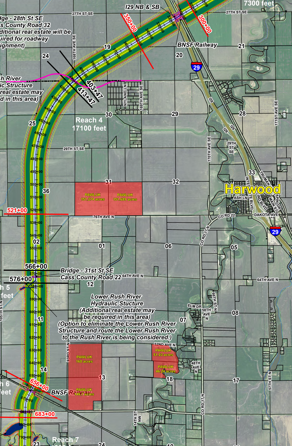
• There are 706.922 acres of property listed under the last name Pawluk west of the Sheyenne River and north of 32nd ave NW that are registered to the same Fargo, ND mailing address.
• The taxable valuation as of 2014 was $747,000
• This is an area prone to flooding.
• Pawluk land will benefit from a project decisions made by Cass county and the Fargo Diversion Authority
• Ken Pawluk is a Cass County commissioner, and has done so since the inception of the diversion project.
• Ken Pawluk is a voting member of the Fargo Diversion Authority and Public Outreach Committee.
• Ken Pawluk had the “opportunity” to exercise his will with greater representation in the DPAC assessment vote, both as a property owner and as a Cass county commissioner on the 706.922 acres registered to his Fargo, ND address.
Coming soon: Pawluk’s Pen Perils (part 5)
Views: 183