Richland-Wilkin Joint Powers Authority
Original Publication Date:
October 4th, 2012
Wahpeton Daily News
Republished with permission from:
Author: Trana Rogne, committee member Richland Wilkin JPA and board member Mndak Upstream Coaltion
Gone are the days when the word “dam” was not uttered by the members of the Fargo Diversion Authority. No longer is “control structure” used as some junior league public relations effort to down play the negative aspects of Fargo’s diversion plan. Nowadays it’s a dam.
Nowhere is this more apparent than in the question posed by the U.S. Army Corps of Engineers to the Fargo Diversion Authority: “USACE has requested local sponsor’s plan for at what flow the control gates on the Red and Wild Rice would be opened to protect the dam?” (See Fargo Diversion Authority board meeting packet, July 12, 2012). The Diversion Authority, to our knowledge, has not responded to this request.
According to FEMA, as a high hazard dam: “The failure or mis-operation .. will likely result in loss of life.”
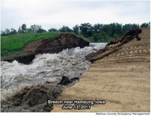
“It is important to remember that, while the software shows a life loss of 31 people during the day for the 100-year breach, extreme upper warning scenario, those fatalities are spread across approximately 2,700 structures in the study area,” said the Army Corps. (See Corps’ document Levee Breach and Loss of Life, June 29, 2011). One would conclude that the Corps rationalizes the 31 lives lost is what you would expect with 2,700 structures in the study area.
This controlled release of water to protect dams has recently been used in Minot and Bismarck, flooding many uninsured home owners, schools and businesses. Controlled releases have involved exploding holes in levees, as in New Madrid, Mo., where the holes were blown in the levees to prevent much larger losses.
The present plan does not provide for the answer to the question, when are the gates opened to protect the dam? An operation plan with specified flow rates, an evacuation plan and an emergency notification network is needed now, not after people are put in harm’s way. The new plan Fargo rolled out on Sept. 13 proposes to hold more water upstream from Fargo, 1.5 miles closer to Fargo with less evacuation time.The 240,000-acre feet of water that Fargo proposes to hold behind this dam amounts to three times the water the Bald Hill dam holds.
A better solution is basin wide retention where smaller amounts of water is temporarily detained in multiple sites. A failure in a dam or levee at one of these sites has negligible effect on flooding at Fargo.
These matters must be settled before North Dakota contributes any more state tax dollars.
Views: 207