Various Project Alignments
Download: Tag Final Option Map
Final Comments of Cash Aaland following the four meetings of representatives of the Richland-Wilkin JPA, the Army Corps of Engineers, and the FM Diversion Authority hosted by the Minnesota DNR in St. Paul, MN and concluding on March 8, 2018.
When the Minnesota DNR denied the FM Diversion Authority’s Dam Safety and Work in Public Waters Permit Application in October of 2016, it did so for very specific reasons. Chief among them was that approximately 54% of the lands removed from flooding in the project’s proposed 72,923 acre benefited area were “sparsely developed flood plain located outside of Fargo.” (Para 36, 154 and 196, Dam Safety and Public Waters Permit Application 2016-0386, Findings of Fact, Conclusions and Order). The proposed high hazard dam, necessary only to mitigate downstream impacts caused by the destruction of so much flood plain storage, would have resulted in the inundation of approximately 20,000 acres of land that did not previously receive flood waters. (Para 34, Findings and Order). The plan: “simply shifts the burden of flooding from one sparsely developed rural area to another and, to this extent, is of minimal benefit to the public welfare.”(Para 196, Findings and Order).
The DNR concluded that “[t]he review of the economic analysis and flood control benefits performed for the proposed project does not establish that the quantifiable benefits support the need for the project” as required by MN statute. (Para 137, Findings and Order). “Constructing a Class I (high hazard) dam is neither reasonable nor practical in light of the incremental increase of flood protection afforded to existing development in the F-M metro area.” Id. The FM Diversion Authority failed to establish that its proposal represented the “minimal impact solution” with respect to all other reasonable alternatives as required by MN statute. (Para 85, 198, Findings and Order).
At nearly every meeting of the Fargo-Moorhead Area Flood Diversion Task Force Commissioner Landwehr cautioned everyone present that the “current” project was not permittable and that “major changes” must be made before a permit could be issued. The words “major changes” were repeated by Governor Dayton in his written statement in the Task Force Final Report and again by the Commissioner during the subsequent meetings held in St. Paul with leadership representatives from the Army Corps, the FM Diversion Authority and the Richland-Wilkin JPA.
The Richland-Wilkin JPA, having carefully noted the findings and comments contained in the order denying Fargo’s permit application as well as the recommendations of hydrologist Charlie Anderson, proposed major modifications to the FM diversion footprint.
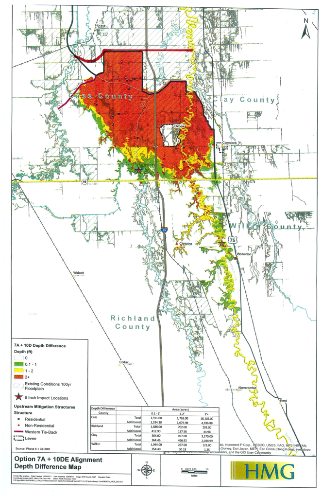
The JPA’s proposal would reduce the size of the project from the 72,923 acre plan that was denied a permit, to a 49,000 acre plan that would leave unchanged the plan’s specific features that protect the existing development in the FM Metro. (Para 154, Findings and Order). The JPA’s proposal also allows a reasonable area for future growth. The northwest modification proposed by the JPA would preserve the flood plain of the Maple and Rush rivers northwest of the Metro area. By reducing the length of the diversion channel and moving it east, approximately 29,400 acres of sparsely developed flood plain would be excluded from the project footprint, maintaining its natural flood plain storage capacity. Existing development in this rural area would remain “as is” and not receive any additional waters. The JPA’s proposal on the southern end of the project would move the dam a reasonable distance north preserving another 10,000 acres of rural flood plain. Charlie Anderson modeled, and the TAG summary acknowledged, that the JPA’s proposals would lower the staging area elevation by 5.4 feet to 916.2, wholly removing impacts from Richland and Wilkin Counties and greatly reducing Minnesota impacts in Clay County.
At the final leadership meeting on March 8, Kent Lokkesmoe acknowledged that if, in addition to the JPA’s proposed modifications, another 6 inches of flow downstream was allowed as suggested in the Task Force Guidance for TAG, the result would reduce staging by another foot or more, wholly removing Oxbow Hickson Bakke from the staging area and potentially eliminating all the Minnesota impacts. The elevation of OHB is approximately 915 to 916.5. The new houses from the ring dike buyouts on the south side of the community are constructed to an elevation of 918.
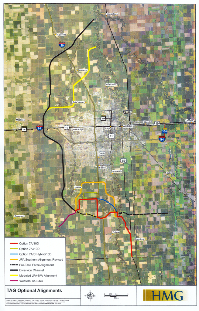
The Army Corps and Diversion Authority went a different direction. In the press release circulated at the last Leadership meeting on March 8, and forwarded to the media the next day, Diversion Authority leaders announced their decision to seek a permit on Option 7A/10D (view map). The Diversion Authority formally announced it would seek a permit on this alignment following a Diversion Authority board meeting held Friday, March 16. Option 7A (view map) is the alignment promoted by Diversion supporters at the December, 2017, final meeting of the Governor’s Task Force, and for which Commissioner Landwehr indicated was not substantially different from the initial project to qualify for a Dam Safety permit. The initial project was objectionable primarily because it would permit development “in over 39,000 acres of sparsely developed natural floodplain on the outskirts of the F-M metropolitan area.” (Para 160, Findings and Order).
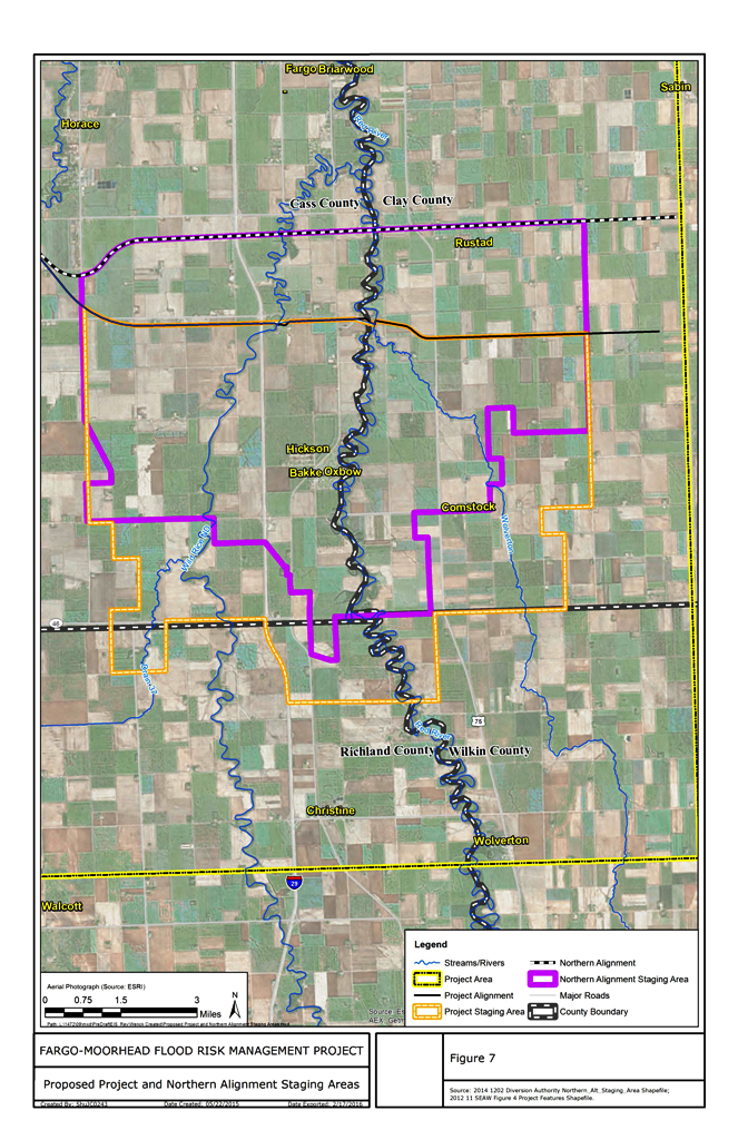
Fargo’s proposed Plan B, as outlined in the Diversion Authority’s press release and the TAG documents reflecting the size and shape of 7A/10D (view map), would actually increase the Diversion project from the 72,923 acre project that was denied a permit, to a 76,812 acre project with the dam located further south. (Para 36, 154 Findings and Order)(TAG spreadsheet: FM Diversion Project – Southern Embankment/Dam Option Comparison). The Northern Alignment Alternative (view map), proposed for permit by the DA in their 2016 Dam Safety and Public Waters application, and upon which the DNR Denial Order was tied, proposed the dam and embankment be located 1.5 miles further north than that proposed by 7A10D (view map). I have attached two maps to illustrate this point. One shows the location the high hazard was proposed in the alignment that was denied permit. (Northern Alignment Alternative) (view map). The second depicts with a red line where the denied dam location was relative to Fargo’s current 7A/10D proposal. (7A-10D) (view map).
The Governor’s Task Force and the subsequent Leadership/TAG meetings held over the past six months created an opportunity for the FM Diversion Authority leadership to get feedback directly from the Minnesota DNR as to what a lawful and permittable project would look like. Following the conclusion of the Governor’s Force, and at the first of four “leadership group” meetings in St. Paul, the Commissioner outlined a procedure whereby, after the various options were studied and discussed, the DNR leadership would provide a good indication of whether any of the TAG vetted alignments might pass the statutory hurdles allowing the issuance of a Dam Safety permit. Indeed, the whole purpose of the meetings, and the reason for the DNR dedicating substantial time and resources, was to provide the Diversion leaders this feedback at the end of the process at the March 8 meeting.
The Diversion leaders and Army Corps representatives wholly squandered this opportunity. Rather than explore or propose major changes, they elected to use everyone’s time to try to re-litigate, ad nauseum, the details of their failed proposal. Ignoring the repeated warnings of the Commissioner and his staff that nothing less than major changes would do, the Diversion leadership proposed a project with a bigger foot print than what the DNR previously rejected. (Para 158, Findings and Order). They did so in a manner insulting to process by distributing a press release created before the final meeting, prior even to the engineers of the TAG group completing their comments and suggestions or communicating them to Kent Lokkesmoe. The Diversion Authority and Army Corps leadership thus effectively signaled that they cared little about what might constitute a lawful or least impact solution, or even what the Commissioner’s opinion might be. In fact, by circulating the press release and DA decision mid meeting, prior to any discussion or alignment feedback, the Diversion leaders made evident their contempt for the generous contribution of time and efforts made by the DNR leadership and staff through the Governor’s Task force and the subsequent TAG and Leadership Group meetings. Maybe that was the point. Maybe Mayors Mahoney and Williams wanted to pre-empt the words: “cold, ice cold.”
The Richland-Wilkin JPA has always maintained that the original NED plan was a reasonable less impact alternative that should serve as the true baseline for comparison. The NED plan proposed a simple Minnesota side diversion, one-half the size of Fargo’s plan, which fully protected the FM Metro while preserving the existing flood plains both North and South of the cities. This cost efficient alignment, with its inlet north of the Wild Rice / Red River confluence, stands as proof that Fargo’s past or current 7A/10D (view map) plan cannot survive the “least impact solution” test required by Minnesota statute.
The JPA proposal that emerged from the Task Force/Leadership meetings would also preserve valuable flood plain, fully protect the FM Metro, and has a footprint of 49,000 acres as opposed to Fargo’s 7A/10D (view map) plan that covers 76,812 acres. The JPA’s recent proposed northwest and south modifications to the project, which were vetted by Charlie Anderson and the TAG group, are further proof that Fargo’s current “plan b” is not a “feasible, prudent, and minimal-impact alternative to provide flood protection to the F-M metropolitan area” with respect to all other reasonable alternatives. (Para 85, 198, Findings and Order).
Respectfully Submitted
Cash H. Aaland
|
|
|
| Download: 7A – 10D | Download: Northern Alignment Alternative |
Views: 888