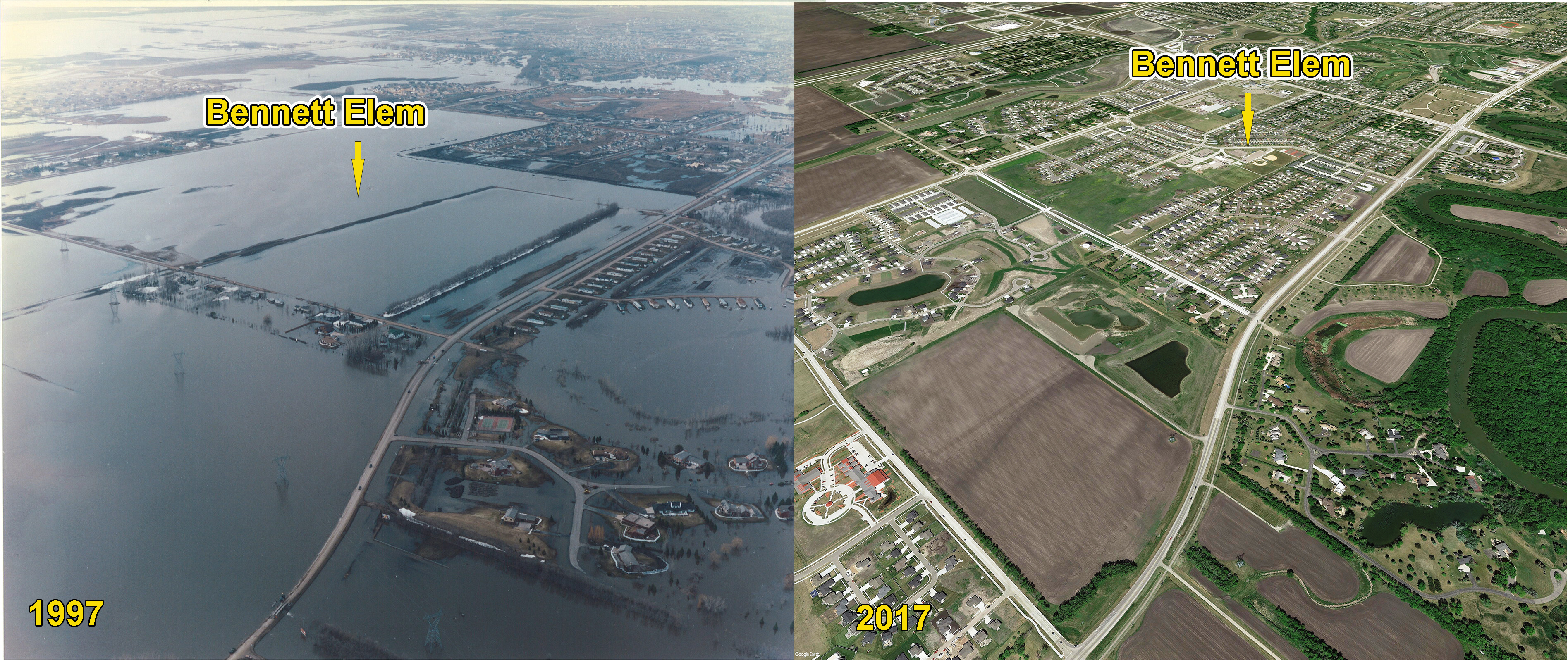
Bennett Elementary, Fargo, ND
Twenty-five years ago, there was a political adage coined that said, “It’s the economy, stupid.” In the hunt to get a permit for the Fargo-Moorhead diversion from the Minnesota Department of Natural Resources, the proverb is, “It’s the floodplain, stupid.”
When Minnesota Department of Natural Resources Commissioner Tom Landwehr presented guidelines to the Governor’s Task Force on the diversion last November, he and his staff were emphatic about what Minnesota law required if a permit was to be issued. He highlighted state statutes that said, “It is the policy of this state to reduce flood damages through floodplain management….” And, “A public-waters-work permit may not be issued…if the project does not conform to state, regional and local water and related land resources management plans.”
Minnesota statute says, “the proposed project must represent the minimal impact solution to a specific need with respect to all other reasonable alternatives.”
Following the end of the Task Force, the Richland-Wilkin Joint Powers Authority hired a highly-respected engineering firm to model a diversion alignment that would fully protect the Fargo-Moorhead metro area and comply with Minnesota law. The result was a diversion channel that runs much closer to the boundaries of the cities, and has less impact on areas upstream.
Modeling conducted by the JPA and confirmed by engineers from the Diversion Authority and DNR, show that by changing the alignment, very little effect would be felt in Minnesota, and upstream impacts would not reach Wilkin or Richland Counties.
The southern edge of the wave would fall just short of Hickson-Bakke-Oxbow. Floodplain impacts would be one-third those of the original proposal denied a permit by the DNR.
The Diversion Authority doesn’t seem concerned about floodplain impacts. Their revised project’s main feature is a 20-foot-high dam that runs on the west side of Minnesota Highway 75 in an effort to keep water out of Clay County, and increase flooding in Cass, spilling overflow to the south into Richland and Wilkin. Their reduction in floodplain impacts come primarily from changing flood flows from the higher EOE, or ‘hypothetical’ flood levels, to an historically based flood risk used by FEMA. The DNR has stated that over half the benefited area of the original project was sparsely developed rural area, and their laws don’t allow for that.
It’s the floodplain, stupid. All the buzzwords of structure counts, assessment districts and cost benefit ratios take a back seat to what the DNR has said repeatedly, directly, and in writing. Minnesota law requires that only the plan that protects infrastructure, and the currently developed area of Fargo-Moorhead, with the least impact to the environment and floodplain, can be legally permitted in their state. A federal court ruled the state had the legal right to make that determination. Ignoring the obvious doesn’t provide needed flood protection.
It’s the floodplain.
by: Trana Rogne and other members of the Richland-Wilkin Joint Powers Authority editorial team.
Views: 316