
The Fargo Diversion Authority, Cass County entities and U.S. Army Corps of Engineers have disseminating volumes of misinformation in an attempt to sway public opinion into supporting the multi-billion dollar Fargo Dam and FM Diversion project.
At the center of their false claims is the level of flood experienced in 2009. During the event and in the months following the 2009 flood, there was little question that the Fargo Moorhead area experienced a significant flood greater than a 100 year level. However, the flood level in 2009 had more to do with reduction of flood plain benefit than additional water present in the river systems.
Irresponsible development into the flood plains south of I-94 forced the Red River gage over 25.2 inches higher in 2009 when comparing the 1969 flood and referencing the same water discharge.
Instead of limiting further development into the natural flood plains south of Fargo, borders were extended even further with the multi-million dollar Davies H.S. project which has fostered more encroachment into the natural flood plain, displacing more water onto other Fargo residents.
Natural flood plain encroachment is the root cause for the NEW mandatory flood insurance requirements that many property owners have received in the past few months.
In attempt to generate support for the recent tax assessment rolled out by the Cass County Joint Water Resource District, the Fargo Diversion Authority and Cass County have revived a false and misleading 2009 flood event.
Below is a slide taken from the tax CCJWRD assessment presentation:

CLICK IMAGE FOR LARGE VIEW
Here is Page 17 from Appendix D “Hydaulics and Hydrology,
U.S Army Corps of Engineers EA Document (2014):
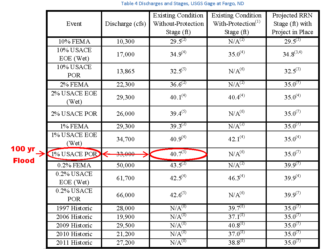
exceeded the USACE (POR) Period of Record 100 year flood event.
CLICK IMAGE FOR LARGE VIEW
Isn’t it curious the 2009 flood crest exceeded the U.S. Army Corps of Engineers Period of Record (POR) 100 year flood event, yet, local officials use fear and intimidation tactics to sell the 2009 flood event as a 50 year event?
If you would like your concerns heard about this unjust tax assessment scheme, comment below, on facebook or attend the tax assessment hearing:
Tuesday, March 31, 2015 (Statuary Project Hearing)
Fargodome
Fargo, ND
5:30 pm-7:30 pm
Views: 222
we dont need this unjust project find cheaper ways to protect fargo grandforks put up flood walls why cant cass county learn from their example why our taxes are high enough and now you want to assess us for this unneeded project i say WE DO NOT NEED THIS PROJECT