Richland-Wilkin Joint Powers Authority
Original Publication Date:
December 12th, 2013
Wahpeton Daily News
Republished with permission from:
Blain Johnson is a 2012 graduate of the NDSU Emergency Management program and is currently studying for his masters in biodefense at George Mason University
Why doesn’t Fargo change its flood stage?
On Dec. 23, the river gauge in Wahpeton will have flood stage increased from 10-feet to 11-feet. It will also increase moderate and major stage by 1-foot each.
What is with the change?
The stages are set by the officials of the jurisdictional boundary the gauge is placed, in cooperation with the local National Weather Service office. The adjustment was agreed upon due to increased flood protection the cities of Wahpeton and Breckenridge have dedicated funds to since 1997. The new levels reflect better protected, prepared and capable cities.
Of all the cities in the area that have spent money on flood protection in recent years, Fargo and Moorhead, Minn., top the list. Since 2009, there have been 25 miles of permanent levees constructed throughout the cities, and more than $200 million spent on increased protection. In Moorhead, a flood that would require 670,000 sandbags in 2009 would only require 33,000 today – the situation is similar in Fargo.
This spring, the Grand Forks National Weather Service office approached the city of Fargo about changing their flood stages, and the city said, “No thank you.”
Why would a city that has charged a half cent sales tax during the past three years, at the cost of millions of dollars to local taxpayers, choose not to have these funds reflected in a more prepared community by raising the flood stage?
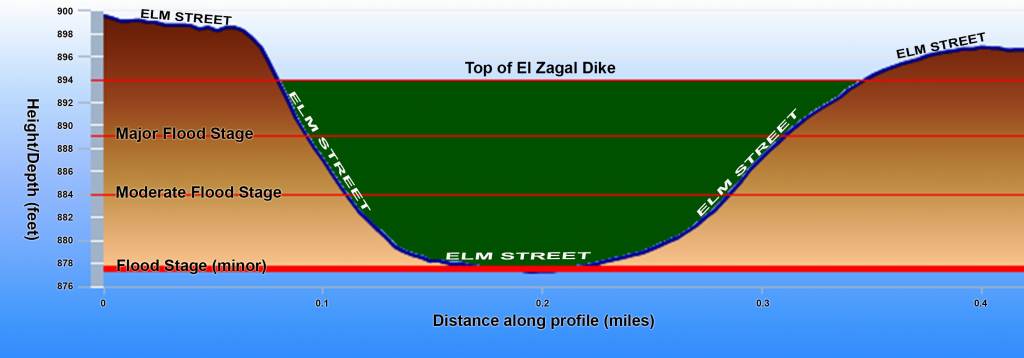
According to the National Weather Service, the only real effect of a flood under 22 feet is a piece of Elm Street that is threatened at 18 feet, the basis for the current flood stage.
So, 300 yards of Elm Street causes enough of a disruption to a city nearly 50 square miles in area to justify a ‘flood’?
The city of Fargo spent $2 million to prepare its citizens against the 2013 flood, which at 38-feet would have been the fifth highest on record – less than 1,000 times the cost of the proposed diversion. The 1997 flood that devastated Grand Forks cost the city $2.1 billion dollars – adjusted for inflation.
So, if the dikes happen to fail during a large flood in Fargo, would the city even incur enough damages to justify the original cost of the Diversion?
The cost/benefit ratio is simply too low on this project for it to be seriously considered.
What is behind this refusal to change the stages on the Red in Fargo?
Is it because the 300 yards of Elm Street is an integral part of the city’s infrastructure that a rise to 18-feet can be considered a key disruption?
Or is the refusal rooted in a deeper plan which involves a costly flood protection project for Fargo to seemingly prevent the ‘major’ floods from continuing to happen?
Flood stages should be used as a tool for community awareness and not as a bargaining chip to subverse citizens and legislators. Fargo should follow Wahpeton’s lead and adopt more representative flood stages.
Views: 65