In a mere 4 days, news-media in Fargo reported on the Red River going from Watch to Warning, but are now beginning to downplay the “warning”.
Could it have anything to do with the significant snow storm, that the National Weather service had potentially forecast, entirely missing the metro area?
Kim Hyatt, WDAY article from Apr 5, 2018: (Read more…) “There’s a potential for more snow Friday, April 13. Of course, that doesn’t sound good” – Vince Godon, National Weather Service meteorologist.
By April 11, 2018 – Nick Broadway, WDAY reported (Read more…): “METRO—By Sunday, parts of the valley will be in a Flood Watch. The National Weather Service predicts by Sunday afternoon water levels here at the Red River will stay just below the point of hurting buildings and farmland.
Seeing that most of the moisture fell outside the Red River Basin and would not significantly affect communities along the Red River, the narrative began to change. Bailey Vertin, WDAY reported on April 15, 2018: (Read more…) “METRO — Tides are rising on the Red River. As temperatures rise, so does the water in the Red River. Fargo is in a flood warning right now, but meteorologists say, it might not be as bad as you think.
“Never let a good crisis go to waste…”
| So why, exactly, is Fargo pounding their tribal flood drums? |
It is the battle-cry of public works projects, in part, because it relies on “pain in the present” as a call to action, wherein, reasonably level-headed people submit to hysteria and fear mongering to avoid a perceived threat or inconvenience.
| Listen to this Jan 12, 2017 excerpt from Jordan Schroeer, WDAY (Read more…) interviewing Mayor Tim “it’s gonna flood” Mahoney on the 2017 State of Cities event. |
| Fast forward to this Nick Broadway, WDAY news clip from April 11, 2018: (Read more…) |
| Pro-Diversion FMDA zealots (Read more…) routinely use fear of a mythical flood (Read more…) potential or FEMA flood insurance rates (Read more…) to impart fear. Audio clip from the December 10th, 2014 Public Outreach meeting: |
When you hear the laughter…, remember the overstated flood forecasts that Fargo has missed every flood since 2009…
| December 10th, 2014 Public Outreach Transcript Excerpt |
|
| Ken Pawluck: | part of it depends on when the next flood is, because, because, the floods are really what drive the activity, and if we have a flood this next spring, that, that, that will drive more activity than if we don’t have any flood as far as action by the feds and, and reaction. |
| Kevin Fisher: | but unfortunately that would help our case to if we had that to get the diversion in, yet we don’t want a fl.. we, we, we really don’t want a flood. |
| Ken Pawluck: | we don’t want the flood, but ya know what…, we have zero control over that happening. |
| (laughter) | |
| Rodger Olsen: | but the in…, insurance threat might be our…, conduit to…, continuing this forward, and, and giving us the support that we, y’know, we’re looking for. |
| Rocky Schneider: | I think like you said, I think there’ll be, there…there… y’know positive outrage once those letters come out about… Why am getting this letter? Why hasn’t something been done? I think this is a positive thing because I think that’s… that’s what everyone’s working toward. |
| Kevin Fisher: | especially when we get that homeowner that all of the sudden is being transferred to wherever and has got to sell their house and they didn’t take out the flood insurance…, now they try to sell it and they are like “what!-?” how come I didn’t that’s what this is going to cost ya…, and it’s like well…, y’know…, call the people to be and let’s get it done. |
The most recent flood forecast is a non-starter. It is simply empty headlines that compliment the pro-diversion agenda – ironically while the FMDA and Upstream await the Minnesota DNR determination on whether “Plan B” should be vetted further or sent back to the drawing board.
However, the greater issue at hand is the predication of fear tied to the Red River.
Yes, the Red River needs to be respected, however, Fargo and Cass county have failed miserably in restricting river flood-way setbacks and have pathologically encouraged encroachment (Read more…) into the last natural flood plain thaing protects Fargo. Fargo and Cass county planners are creating future floods and your future flood insurance requirements via negligent flood management (Read more…).
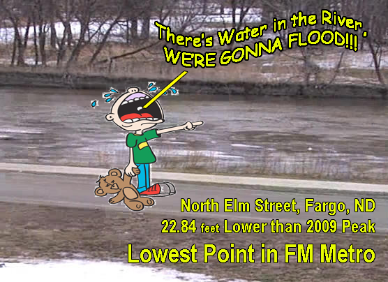
With the flood forecast of 18.5 feet (when this article was written) predicted to crest on April 21, 2018 – the FM metro area has little to be concerned about. Being that 18.5 feet is 22.34 feet lower than the 2009 flood event and presents very little factual threat to the FM area.|
The NOAA (National Oceanic and Atmospheric Administration) aka National Weather Service maintains information on Red River Gages (Read more…) .
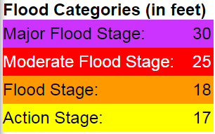
The Fargo, ND page includes Flood Categories, Current River Conditions, Historical Record, which also includes a list of gage elevations that relate to potential impacts in the FM Metro Area.
Based on the information provided by NOAA and Fargo, ND the flood crest of 18.5 feet expected on April 21, 2018 requires only that a pump station to be started at Island Park and a one block stretch of Elm Street between 14th & 15th Avenue (Read more…) to be potentially closed. This may cause a 2-3 minute longer commute for a few North Fargo residents during the brief detouring of traffic.
| Fargo River Gage – Impacts and Actions Cited Source: National Weather Service |
|
|---|---|
| 17 | Forecast Service Stage. Fargo…Water rises to the edge of the bike path at El Zagel bowl along Elm StreetNorth between 14th and 15th Avenues.Bankfull Stage. |
| 17.7 | Fargo…Sanitary Sewers affected.Pump station at Island Park is started. |
| 18 | Flood Warning Stage…minor. Fargo…Elm St between 14th and 15th Avenue N is closed. |
| 19 | Fargo…Low-level dam south of Main Avenue is underwater. |
| 22 | Fargo…North Broadway bridge is closed. |
| 23 | Fargo…North Broadway bridge floods. |
| 24 | Fargo…2nd Street N closes between 1st and 6th Avenue North for construction of temporary dike that protects City Hall if the river is forecast to rise above 31 feet. |
| 25 | Moderate Flood Stage.Fargo…City Parks and Recreation areas along the river begin to flood. |
| 28 | Fargo…F-M toll bridge over RRN closed (12th Avenue N). Construction begins on the dike to protect sewage treatment plant if forecast is above 34 feet. Moorhead…F-M toll bridge over RRN closed (15th Avenue North). |
| 30 | Major Flood Stage. Fargo…Flooding at 2nd and 3rd Avenue North areas. 2nd Street South closed between Main Avenue and 4th Street. Temporary dike constructed on Oak Street dikefrom 87th Av. N to 11th Av. N. Moorhead…Water crosses entrance road to Gooseberry Mounds Park. |
| 31 | Moorhead…1st Avenue North underpass is closed. |
| 32.5 | Fargo…Bridge at 1st Avenue and 2nd Street North closed for construction of temporary dike on 2nd Street. 1st Avenue North bridge across Red river closed for construction of temporary dike across 1st Avenue North. Moorhead…1st Avenue North bridge is closed. |
| 33 | Fargo..1979 Design top of dike at El Zagel golf course. Moorhead…Start diking to protect the Hjemkomst Center. |
| 34.4 | Fargo…Northern-Pacific…Center Avenue bridge clearance. |
| 35 | Moorhead…Actions taken to prevent storm sewers from backing up. |
| 36 | Fargo…Sandbagging starts if the river is forecast to rise above 38 feet. |
| 36.29 | Fargo…Clearance height of 1st Avenue bridge. |
| 37 | Fargo…Convent Bridge at 52nd Avenue South is closed. |
| 40 | Moorhead…Red River is lapping at the base of the Heritage Hjemkomst Interpretive Center.Fargo…2013 Top of emergency SANDBAG levee. |
| 40.82 | **** Record Crest March 28, 2009 (instantaneous measurement) **** |
| 42 | Fargo…2013 Top of emergency CLAY levee. |
| 43 | Fargo…Top elevation of 4th Street permanent levee. |
| 45 | Fargo…Top of VA Medical Center’s flood Wall. |
The mayor and his ilk that cry “flood” could learn a thing or two from Aesop’s Fable of the Little Boy that Cried Wolf.
Just remember, it’s Fargo’s fault for developing natural flood plain, restricting the river flood-way, displacing water and causing Fargo flooding…, and the Red River was here long before the un-civilized built any infrastructure.
It’s time for Fargo to grow up and complete internal flood protection and to stop behaving like immature children looking for attention and handouts.
Views: 1013
Thank you for the article! I am so sick of it. Valley News Live is the worst with their scrolling warning and watch all weekend – FAKE NEWS!
Not only am I looking to move outside of the FM Dam but outside of Cass County and the cronies. Unfortunately, Cass County is so large. It should be split up.