Did Oxbow, ND get thrown under the bus by the FMDA (Fargo Moorhead Diversion Authority), ND State Engineer and the USACE (United States Army Corps of Engineers)?
Having served as the Bakke OHB-PDT representative since 2013, I have watched the OHB (Oxbow, Hickson, Bakke) ring dike-levee project develop over the course of 56 teleconferences and other face to face meetings.
OHB stands as a testament to the FMDA trying to buy-off an upstream community’s leadership and silence to claim upstream concerns were addressed. The initial $65 million project is currently 100 percent over budget ($132.5 million) with the potential of another $40 million to complete.
The OHB component construction began prematurely ~ long before overall designs were finalized or any shovel of dirt was turned for any other aspect of the FMDA project which placed the OHB project on a collision course with the man-made flood-way being created around the communities left within the dam staging and storage reservoir.
| FEMA Levee Mapping Citation | Accredited Levees Still Present Residual Risks |
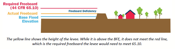
| Even after the Professional Engineer certification and FEMA accreditation processes are completed, there is still a flood risk associated with levees. While levees are designed to reduce risk, even properly maintained levees can fail or be overtopped by large flood events. Levees reduce risk, they do not eliminate it.(read more…Page 3) |
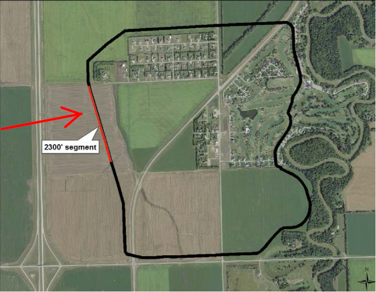
The USACE report stated that the top of levee for OHB must be adequately above the overflow spillway embankment along of 922.5 feet (read more…) (located to the west along Cass 17) and designated the OHB ring-dike levee with a top elevation of 926.5 feet and a 2,300 foot section along the western edge at 925.5 feet as an overflow section (read more…) to allow the OHB protected area to fill to prevent failure of the OHB ring dike levee from reaching the top of the OHB ring-dike levee.
FMDA Plan A, which was denied a MN DNR permit, morphed into FMDA Plan B after the Governors Task Force meetings in 2017 which removed considerable impacts from Minnesota but at the same time creates new severe impacts for some Minnesota property owners not previously impacted by the FMDA project.
The biggest issues created for Oxbow, ND between Plan A and Plan B is that there is a minimum 1 foot loss of free-board for the communities that remain within the staging and storage reservoir of Fargo’s dam, placing the entire OHB project at risk if not properly addressed and the alleged removal of the non-mechanical emergency spillway prevent water to rise beyond the elevation presented in all previous documentation.
|
• |
September 2011 the USACE indicated that the emergency spillway would be robust and resilient to ensure safety and avoid risk of project failure.
Page 109 Main FEIS emergency spillway (read more…) |
|
• |
March 2014 the USACE released OHB Appendix C which contains a Final Recommendation of 4 feet of freeboard at Oxbow, ND and the OHB project (read more…). |
|
• |
March 2019 the USACE released their Supplemental Environmental Assessment which indicates the maximum water surface elevation at the Red River dam to be 923.65 feet (read more…). |
|
• |
March 2019 the USACE was unclear if 923.5 feet or 924 feet (read more…) would be the over-topping elevation of the Western Tie-Back dam reach. |
|
• |
August 2019 the North Dakota construction permit (page 3) indicates an emergency spillway of 923.5 feet (read more…). |
|
• |
Jan 2021 Aaron Carranza, ND State Engineer (read email…) and Joel Paulsen, Executive Director FMDA (read email…) both claim there is no emergency spillway. |
|
• |
March 2021 USACE issues Western Tie-Back plans with the lowest elevation of 924.00 feet (read more…). |
So where does that leave Oxbow, ND?
Both FEMA (read more…) and the USACE (read more…) indicate that a minimum of 3 feet of free-board or greater is required, yet the water elevations from the USACE indicate much less protection for Oxbow, ND.
If FEMA and the USACE use the lowest possible elevation of a dam or levee as stated level of protection, then the same must be applied to OHB ring-dike levee. The Western Tie-Back plans released in March 2021 indicate the lowest reach of the dam at the Western Tie-Back dam location to be 924 feet, which is arguably the reference control point for the flood threat potential posed to Oxbow, ND because the water can keep rising in the reservoir until in begins to overflow at 924 feet. Keep in mind, the water surface increases along a general profile per mile upstream of Fargo’s Dam.
Even more concerning is the effect of wind wave run-up, over-topping and potential failure (read more…) that could occur at OHB, given the shallow nature of the reservoir (read more…) surrounding the communities and the winds that drive wave action. A small pond in Oxbow, ND along Hwy 81 routinely experiences white-cap waves and that pond is approximately 300 feet long. The reservoir around OHB extends for miles in all directions.
The entire “southern embankment” consists of three concrete dam control structures with operable tainter gates and nearly 12 miles of earthen dam with 5 feet of freeboard and a Western Tie-Back and Eastern Tie-Back over-top reach (read more…) to prevent water from reaching Fargo.
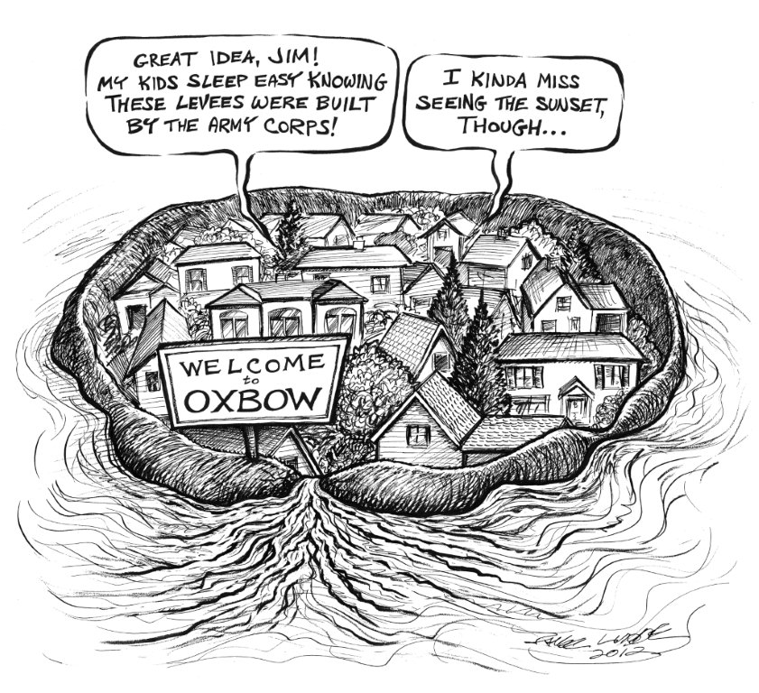
The water in the reservoir is expected to surround the communities of Oxbow, Hickson and Bakke with mere inches of free-board and the USACE, ND State Engineer and FMDA proponents have chosen to disregard vital free-board standards creating a new design risk for Oxbow, ND as a result of the Class 5 – High Hazard Dam being constructed for the primary benefit of Fargo, ND.
On March 3, 2021 Terry Williams, USACE acknowledged (read more…) that the pool elevations at the OHB ring levee are slightly higher with Plan B than with Plan A but she claimed the freeboard is still sufficient.
| Plan B Staging Elevations at OHB – 0.5 mile Intervals PMF Date Source: USACE Final SEA March 2019 |
||||||
| Distance From Dam |
Point of Reference |
PMF | Inches of Freeboard |
Western Tie-Back |
Inches of Freeboard |
Top of OHB Overflow |
| 0 miles | Dam | 923.650 | 924.000 | 925.5 | ||
| .5 miles | 923.917 | 924.267 | 925.5 | |||
| 1 miles | 924.184 | 924.534 | 925.5 | |||
| 1.5 miles | 924.451 | 924.801 | 925.5 | |||
| 2 miles | OHB | 924.718 | 9.384 | 925.068 | 5.184 | 925.5 |
| 2.5 miles | OHB | 924.985 | 6.181 | 925.335 | 1.981 | 925.5 |
| 3 miles | OHB | 925.252 | 2.977 | 925.602 | -1.223 | 925.5 |
| 3.5 miles | 925.519 | 925.869 | 925.5 | |||
| 4 miles | 925.786 | 926.136 | 925.5 | |||
| 4.5 miles | 926.053 | 926.403 | 925.5 | |||
| 5 miles | County Line | 926.320 | 926.670 | 925.5 | ||
Sufficient to what standard?
The USACE has a long history of kicking the can down the road when the hard questions are asked. Yet, all of the data provided by the USACE, ND State Engineer and FMDA illustrate a different scenario for Oxbow, Hickson and Bakke. Why does it feel like the USACE is going to design the very least protection for Oxbow, ND?
When the USACE released OHB Appendix C on March 21, 2014 – the Final Recommendation (read more…Page 38) was to set top of the Oxbow/Hickson/Bakke Ring Levee Elevation 4 feet above pool elevation of 922.5 feet, but the USACE seems to have ignored that limitation when they designed the Western Tie-Back with the lowest reach of 924 feet.
What was the ND State Engineer thinking when they gave the green light to a construction permit without setting restrictions that would respect the elevation limits at Oxbow, ND?
FEMA must determine if the man-made barriers (read more…) that comprise the man-made reservoir create significantly greater potential impacts that could/would not occur naturally. All of the projections are done on theoretical modeling that cannot be proven accurate until the 100yr, 500yr or PMF event have occurred.
The undeniable fact is that the design plans provided by the USACE indicate a reservoir minimum over-top elevation of 924 feet which directly affects the lowest top elevation of the OHB ring-dike levee.
When/If the overall project is completed;
|
• |
How will the property owners within the OHB ring-dike levee be made whole? |
|
• |
Will these new risks erode property values? |
|
• |
Will FEMA require mandatory high risk flood insurance? |
|
• |
What is the evacuation plan in the event project failure? |
The USACE is specifically vague when it comes the FEMA flood insurance issue and getting a straight answer from FEMA is near impossible on a project that is not yet completed?
The standard answer from the USACE is that in the end there should be “certifiable” flood protection, absent any guarantee.
The vague answer, if any, from FEMA is that they will consider all aspects when remapping is done after the project is completed.
So lets look towards Wahpeton, ND and Breckenridge, MN. After the 1997 flood the communities worked with the USACE to design and build certifiable flood protection, which was largely completed in 2005.
To date, FEMA has not removed the mandatory FEMA flood insurance requirement (read more…) and the certification is not complete.
Over 15 years have passed and the issue of certifiable flood protection still hangs in the balance for areas of Wahpeton/Breckenridge – which are not communities that are going to exist within a staging and storage reservoir behind a Class 5 High Hazard Dam.
Stop and think about this for just a moment…, this has NEVER been done before.
The USACE has never designed a project that crosses multiple river systems with the intentions of leaving 3 communities within the staging and storage reservoir of a dam. There is no precedent for the USACE to rely on that offers any confidence that the OHB project is sound or certifiable with mere inches of free-board.
The question still remains…, how can any property owner within Oxbow, Hickson and Bakke feel confident they won’t face mandatory FEMA flood insurance requirements -or- suffer financial losses due to inadequate free-board in the future, as the slow wheels of certification sit and spin?
If you have concerns regarding loss of freeboard contact:
Representative Jim Schmidt
Chairman, Water Topics Overview Committee
jeschmidt@nd.gov
Senator David Hogue
Vice Chairman, Water Topics Overview Committee
dhogue@nd.gov
Sen. Larry Luick
District 25
lluick@nd.gov
Rep. Alisa Mitskog
District 25
amitskog@nd.gov
Rep. Cynthia Schreiber-Beck
District 25
cschreiberbeck@nd.gov
Rep. Mark Sanford
District 17
masanford@nd.gov
Views: 1467
How much will the 3 helipads one each for Bakke, Hickson, Oxbow add to the overall cost of this Boondoggle?