Mark Broadshaug’s August 11th, 2014 letter to the Fargo Forum is a true indication that the Fargo Diversion Authority is grasping at straws to find any traction it can.
Support continues to dwindle for the proposed project in it’s current form.
The Fargo Diversion Authority has relied on fear of flooding to control how people frame the proposed Fargo Dam and FM Diversion.
As people take a more critical look they begin to question why Fargo should be allowed to grow into flood prone areas at the expense of other resident and areas outside Fargo’s jurisdictional boundaries.
Funding challenges, talk of property tax assessments and further sales tax extensions further erode confidence in an overbuilt, overblown economic development project which does not have final permitting from the Minnesota DNR.
Even more comedic is the absolute arrogance that the Fargo Diversion Authority has displayed towards Minnesota’s governor Mark Dayton and other state representative, which only serves heighten then legal challenges they face.
A much shorter reply to Mark Broadshaug’s letter was submitted August 14th, 2014 to the Wahpeton Daily News, Fargo Forum and Grand Forks Herald. However, to date, the Fargo Forum and Grand Forks Herald have chosen not to run the “abridged version“.
UPDATED: 8/23/2014 | Submitted August 14th, 2014 to:
Wahpeton Daily News – Published August 18th, 2014
Fargo Forum – Published August 23rd, 2014
Grand Forks Herald – ** Not Published **
Here is the un-abridged version to Broadshaug’s letter with commentary:
| Letter: 100-year level not enough By Mark Brodshaug – Aug 11, 2014 Opponents of the Oxbow-Hickson-Bakke ring levee and opponents of the Fargo-Moorhead diversion have suggested that the intended high levels of protection of these projects are excessive and that protection plans should be limited to the size of the flood of record. I write to show the need to plan for events larger than those experienced in the past, and to show support for planning for larger events. |
Mark Broadshaug is furthering the Fargo Diversion Authority agenda of distorting reality and historic flood information to compel support for a proposed project based solely upon hypothetical modeling.
What opponents are really saying is that Broadshaug and the Fargo Diversion Authority are “all wet” about projected flood levels and the need to focus on protecting the city that exists currently and not the natural flood plain they intend to develop in the future.
Excessive…, absolutely! It is irrational to suggest the existing city is at risk and then attempt to nearly double the size of Fargo, ND into land that is prone by the very flooding the city laments.
Whether you are a supporter of opponent of the OHB project of Fargo Dam and FM Diversion, further reduction of the natural flood plain south of Fargo is an unsustainable venture.
| Mark Brodshaug Communities along the Red River have experienced increasing floods since the cities were established. There was a large flood in 1897, but from 1900-42 there were no Red River flood flows that exceeded 8,000 cubic feet per second in Fargo. In contrast, from 1943-96 there were 18 floods in Fargo that exceeded 8,000 cfs. In the short period since 1997, there have been 10 floods exceeding 8,000 cfs including five that exceeded 20,000 cfs. The 2009 flood flows peaked near 30,000 cfs. Flood peaks and frequency have been increasing for more than 110 years. |
The floods examples used by Broadshaug are poor examples used solely for sensational value.
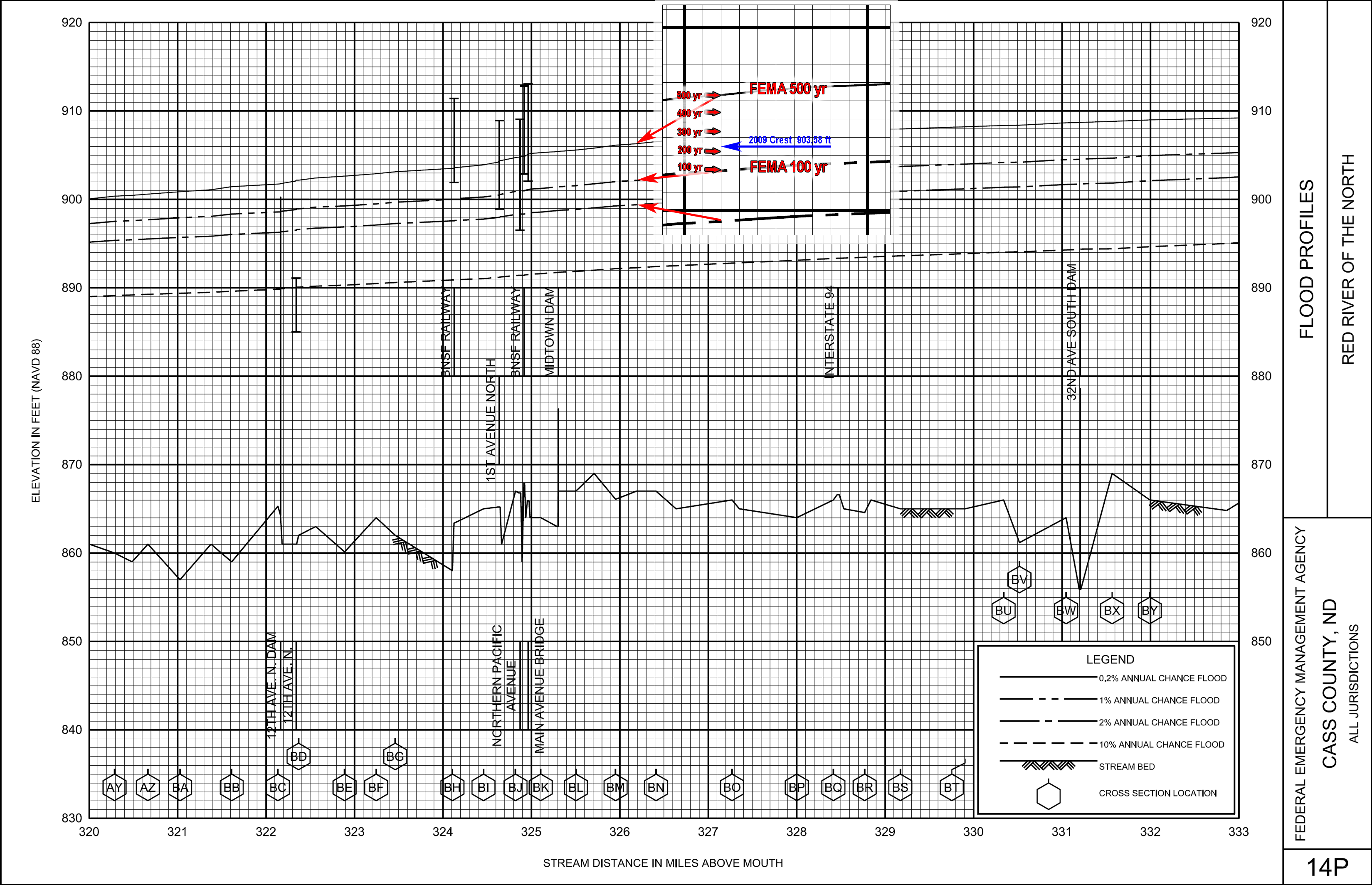
Fact: 8,000 cfs is approximately a 20 foot flood at Fargo, ND. (20.84 feet lower than the 2009 peak crest)
There is no evidence to support that Fargo will continue to experience greater floods than 2009 in the future or that the maximum flood has not already occurred.
Fact: Fargo exceeded the most recent FEMA regulatory 100 year flood level by approximately 11.3 inches in 2009 (around a 200 year FEMA flood event). (Cited Source USGS and 2012 FEMA Flood Insurance Study)
While Broadshaug is postulating an increasing flood threat, neither he or the thousands of pages of U.S. Army Corps of Engineers studies outline the net effect of growth along the Red River which reduces available flood plain and constricts water flow via these cities.
Comparing the 1969 flow of 25,300 cfs to the same cfs flow in 2009 shows a 25.2 inch increase in flood crest. It isn’t more water…, it’s the exact same flow with less area for the water to spread out causing higher river crests and false perception of greater floods.
What Broadshaug also fails to emphasize is that floods less than 30 feet don’t impact 2nd street and most habitable structures are not at risk until around 38 feet.
Had Fargo completed internal dikes, levees and flood-wall protection to 42.5 feet – 117 of the past 117 years would have been non-flood issues. Which could all have been completed for under 500 million. This also a key point for any rational thinker. The entire argument that flood-walls, dikes and levees are not enough falls apart if Fargo would leave the natural flood plain intact because the existing flood plain could easily hold the 150,000 acre feet of storage the Fargo Diversion Authority desperately claims it needs.
Isn’t it ironic that among the thousands of pages of motivated reasoning contained within the U.S Army Corps of Engineers studies that they completely fail to show the amount of potential storage south of 52nd ave in the natural flood plain and what little it would take to double the capacity for nearly 1.5 billion less in costs? (note: the Fargo Diversion Authority 1.8 billion project cost is outdated and invalid)
| Mark Brodshaug Traditional flood planning has aimed for protection from a flood with a 1 percent chance of occurring in a given year or what is better known as a 100-year flood. This is the minimum standard used by FEMA and the National Flood Insurance Program. The Red River Valley should not settle for this minimum protection level and instead should strive for a higher level. |
How naive does Broadshaug think people are? The Fargo Dam and FM Diversion project is not protection for the Red River Valley. It is a multi-billion dollar boondoggle for Fargo’s future development under the guise of flood control that places natural flood plain impacts onto entities outside the city of Fargo’s jurisdictional boundaries without due process, their involvement, vote or approval.
Broadshaug is attempting to denigrate proven FEMA flood standards to bolster support for un-proven higher projected levels.
FEMA uses a contiguous record to assess flood risk, whereas, the Corps study breaks up the period of record into subsets, which is weighted to support an unproven “wetter period”, yet, annual precipitation records do not support that theory.
The U.S. Corps of Engineer and Red River Basin reports failed to include the net effects of flood plain encroachment on rising flood crests and flood risks, which is directly related to new flood insurance requirements. Every person impacted with new flood insurance requirements can thank Fargo for gambling with flood data, dragging their feet on completing internal flood protection and continuing growth into flood prone areas causing greater future flood risks.
There is also no indication that FEMA intends to adopt the Corps modeling as basis for future flood risk mapping.
Fargo isn’t settling for less protection. Fargo can achieve considerably higher level protection by completing permanent flood protection and leaving the natural flood plain intact to provide vital flood buffer for the city.
| Mark Brodshaug The Red River Basin Commission released a report in 2011 titled “Long Term Flood Solutions for the Red River Basin.” LTFS was commissioned by the Minnesota and North Dakota legislatures as a recommendation to the two state governments for flood damage reduction for the entire Red River basin. A link to the report: www.redriverbasincommission.org/Comprehensive_Report_12-15-11_FINAL.pdf |
The LTFS report primary recommendation is to:
| Recommendation for Action 1.1 “…should continue supporting ongoing dike construction, property acquisitions, flowage easements, and flood infrastructure projects to be able to fight at least a 100-year flood, and upwards of a 500-year flood in the long term.” |
Isn’t it ironic that the primary recommendation was not to build a dam, diversion and staging reservoir!
Why is Fargo dragging it’s feet on internal protection that could have been completed by now?
Why hasn’t the Fargo Diversion Authority finalized “flowage easements?
Although the second recommendation is to progress towards a $1.77 billion diversion, the term “diversion” is the key point. If this were truly a diversion and not a Class 1 High Risk Dam, Fargo would have much less opposition to the project.
Any engineer worth their salt could design this project without multiple Class 1 High Hazard Dams to make the project functional. The dams only becomes an integral feature to improve the cost benefit ratio and to accommodate natural flood plain encroachment, which is the growth area that Fargo is fixated upon.
Ever more curious is recommendation three:
| Recommendation for Action 1.3 “Retention upstream of the Hickson and Abercrombie stream gage for a flow reduction of 20 percent (minimum) should be advanced with shared funding by the F-M flood Diversion Authority working with local and joint water boards, using city, local, state, and federal funds.” |
Where is retention in the overall plan? The Fargo Diversion Authority token offering of $25 million towards retention projects is an absolute joke. Even if you placed another ZERO behind that number making it $250 million, it would still fall well short of the $400 million estimate from 2005 to build distributed upstream retention protection that could lower the Fargo gage 1.6 feet (19.2 inches) in a 100 year event.
Curious that two separate studies cite the benefits of distributed upstream retention, which could benefit the entire Red River basin upstream of Fargo is not more widely embraced as a combined alternative for flood protection…
Could it be that the Fargo Diversion Authority really doesn’t care about the rest of the Red River valley? Despite numerous attempts to cite Fargo’s protection as flood protection for the region.
| Mark Brodshaug A flood that breaches the levees at Fargo and Moorhead would cause $3 billion to $10 billion in damage according to the report. A 1 percent chance of that happening is an unacceptable level of risk when the resources exist to lower the probability of disaster. For major urban/metropolitan areas like Fargo-Moorhead, the LTFS report recommends a 500-year (0.2 percent probability) level of protection. LTFS also recommends at least a 200-year level of protection for other cities. |
The $3 billion to $10 billion dollar damage estimate is questionable. Although the report cites: “Estimates for damages to the cities from a lost flood fight at this urban center range from $2.5 billion for a 100-year event to nearly $9 billion for a 500-year event.” It does not indicate whether the flood events are based upon FEMA regulatory floods or augmented U.S. Army Corps of Engineers EOE data.
The damage loss estimates also do not include to what extent inundation would occur in Fargo – Moorhead. The report does not include permanent flood measures constructed by either city, nor does it include water elevation or the extent of property loss. If the damage loss estimates are considering that the metro area would be an entire loss, what would be the actual loss if only 20 percent of the city were inundated?
Floods for Comparison:
Both Cities Located In Narrow Valleys – Unlike Fargo, ND
Nashville, TN 2010
est 11,000 structures incurred major flood damage. (many total loss)
Flood Damage approximately $2.65 billion (USA Today)Minot, ND 2011
est 4,100 structures incurred flood damage (many total loss)
Flood Damage approximately $2+ billion (www.infoplease.com)
Furthermore, there is a difference between a gage flood and a flood plain flood. Fargo’s river gage is confined by a channel of flood walls, dikes and levees on either side of the river. If the dikes and levees were to fail it would take exponentially more water to fill the flood plain on either side of the channel to elevate water to equal a maximum flood event gage height. What would appear to be 5-7 feet higher at the river gage may only equal inches in most streets, which is not much different than a heavy summer rainfall like the metro area has experienced numerous times.
500 Year Flood Risk?
It is extremely disingenuous for project supporters to present a flood risk probability in a misleading manner. You have to consider both sides for a more accurate understanding of the potential risk involved.
A 500-year flood event means there is a 0.2 percent probability of that level flood occurring in any calendar year.
Which also means that there is a 99.98 percent probability of that level flood not occurring in any calendar year…, especially using augmented Corps HEC-RAS modeling based on EOE flood levels that are used to float the “wetter period” argument without substantial evidence in precipitation records to support the EOE theory.
| Mark Brodshaug The International Joint Commission also recommends the use of the 500-year rather than the 100-year interval flood as the measure by which we plan for the future of the basin. According to LTFS, the single urban center that meets the LTFS guideline of 500-year protection now is Winnipeg. Halstad, Minn., Oslo, Minn., and West Fargo meet or exceed the 200-year protection guideline. An additional 15 cities have 100-year protection. Yet, the urban core of Fargo-Moorhead, along with an additional 16 cities, still have less than 100-year protection, according to the study. |
The report does not cite specifically whether or not they have applied FEMA regulatory flood plain standards or the theorized U.S. Army Corps of Engineers EOE flood standards.
Given the fact that Fargo exceeded the most recent FEMA regulatory 100 year flood level by approximately 11.3 inches in 2009 (near 200 year FEMA flood event), it would appear that the LTFS report is not accurate and biased toward non-official “wet period” flood levels.
| Mark Brodshaug This is not to say that Fargo, Moorhead, Grand Forks, East Grand Forks,, Minn., Wahpeton, N.D., Breckenridge, Minn., and other communities in the Red River Valley should not be commended for flood damage reduction projects since the 1997 flood. As significant as these projects are, this work is nowhere near the recommended level of protection these cities need to prevent flood damage from events that are increasing in frequency and intensity. |
Is Mark Broadshaug actually suggesting that these cities increase their flood protections(s) to the higher year levels? If so, would that be FEMA regulatory levels or a contrived levels created via an Expert Opinion Elicitation (EOE)?
Either way, who would fund the venture? At some point, one has to weigh the high cost of living in harms way when the risks are never really eliminated. It is not a question of if a dam, dike or levee will fail…, it is a matter of when.
| Mark Brodshaug In 2011, we witnessed flood destruction in Minot, N.D., and the Bismarck area in developed areas “protected” from 100-year floods. Let’s aim to achieve a minimum of 500-year protection as recommended in the LTFS. |
What Minot, ND and the Bismarck area experienced in 2011 is precisely why Fargo should not continue encroachment into the last natural flood plain south of the city. Flooding in Minot and Bismarck occurred for a number of reasons, the most obvious is way too much water.
However, both cities are downstream of flood control projects that were built to prevent the very scenario that occurred. That false sense of security induced growth into high risk areas and left people exposed when conditions strayed outside the project design(s).
Only a fool would compare Minot and Bismarck to a “what if this happened in Fargo” scenario. What makes Fargo different from Minot and Bismarck is the topography. Both Minot and Bismarck have a valley that is much narrower than the Red River Valley. Where Fargo has over 40 miles east to west for water to spread out, Minot and Bismarck are generally less than one mile wide before the valley rises significantly.
Fargo has a unique topographic opportunity in the surrounding natural flood plain(s) to buffer major events, without exerting excessive impacts onto outlying areas.
To reach a level of destruction in Fargo that Minot experienced in 2011 would require a flood nearly 17 miles wide (46.7 feet). But here’s the catch. It would take nearly 2.5 times the entire 1997 outflow of the Red River Valley to achieve that level.., and it would need to be upstream of Fargo, ND. Put another way – 2.5 times the entire 1997 flood event drainage area of 40,200 square miles would need to occur within 6,800 square miles of watershed area upstream of Fargo.
Again, only a fool would compare Minot and Bismarck to a “what if this happened in Fargo”.
| Mark Brodshaug We should celebrate the F-M diversion project and the Oxbow-Hickson-Bakke ring levee as two big steps toward that recommended 500-year protection. |
On the contrary, Fargo needs to hold city leaders accountable and complete permanent internal flood protection, like the 2nd street floodwall, for the city that exists right now and leave the natural flood plain intact to provide vital flood buffer for the city, rather than spending close to $70 million on the OHB ring dike and creating a nearly 13 mile wide dam and levee that would place a Minot – Bismarck style flood risk immediately upstream of the metro area.
As a resident of Bakke, we’ve never flooded nor has Hickson and all but five homes in Oxbow area are above the new 100 year flood level. In fact, Bakke and Hickson could have withstood nearly twice the 2009 event with relative ease. The same could be said for Oxbow, ND with the permanent flood protection built in 2010-2011 along with temporary measures.
What the Fargo Diversion Authority needs to realize – is that completion of internal flood protection needs to be priority number one to provide Fargo with greater, more attainable, fiscally responsible FEMA regulatory flood protection.
Marcus Larson – Bakke Resident
Bakke Representative, OHB Project Design Team
Views: 232