Richland-Wilkin Joint Powers Authority
Original Publication Date:
December 20th, 2012
Wahpeton Daily News
Republished with permission from:
Author: Daniel L. Zink, Oxbow City Council, member Richland Wilkin JPA.
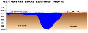
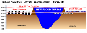
“Natural flood plain” is a phrase that has been getting some attention recently. Flood plains serve as natural flood protection. When a river is allowed to spread out it reduces the height of flood for everyone. Conversely, when a flood plain is eliminated by development, the river level naturally rises in the main stem, impacting everyone in the basin.

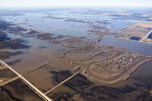
There is a large natural flood plain just south of Fargo. You can link to an aerial picture of this flood plain in action at www.fmdam.org/exhibita.
The photo shows water naturally stored in the area just south of Davies High at a time when the Red River at the Fargo gage was at 38 feet. Engineers tell us that this flood plain is what protects Fargo from the Wild Rice River and that this natural water storage area is what prevented Fargo from flooding in 1997. This flood plain contains a storage capacity of over 100,000 acre feet of flood water.
Imagine the Red River Basin as a cake pan ½ full of water. Drop in a brick and the water rises dramatically. The bigger the cake pan, the less rise to the water; the more bricks, the higher the water.

Fargo’s past ill advised developments have bricked up the Red River cake pan, raising the river levels by eliminating the natural flood plain. Rather than correct this problem by halting flood plain encroachment, Fargo continues to add bricks.
Eagle Pointe First Addition, south east of Davies high is the latest example. Fargo developers, with City approval, are using fill to raise the elevation of this area, which was well below the 39.5 foot 100 year level, forcing the water onto others.

Faced with a problem of their own creation, Fargo leaders devised a way to push the problem onto someone else. Amazingly, Fargo’s Diversion Plan will eliminate the entire flood plain depicted in the referenced photo to the right, destroying over 100,000 acre feet of natural storage, and displacing this water behind a dam four miles south of the area shown. The dam would flood the rural communities to Fargo’s south with 200,000 acre of water. Fargo leaders want to eliminate this flood plain, not for protection, but for Fargo’s future development: more bricks in the cake pan.
What if the problem wasn’t water, but pollution: toxic smog dangerous to life and property, created by Fargo’s poor planning, poor government and greed? Would anyone seriously entertain a solution that would transfer the whole problem onto rural communities, allowing and encouraging Fargo to continue with the same behavior that created the problem in the first place? Would Fargo’s demand that the state spend 100s of millions of dollars to transfer the problem onto rural communities seem reasonable?
We request that rural representatives consider limiting the funds given to Fargo to legitimate flood protection, and deny funding for Fargo’s plan to build a dam to further develop the flood plain.
Related Articles:
FEMA letter to Darrell Vanyo RE: Flood Plain Encroachment
Views: 346
Just as in Minot and Bismarck people are led to believe in the protection of a man made and man operated protection devise, a dam. This dam holds 3 times amount of the water in Bald Hill dam from flooding Fargo. There are better solutions.
The storage area is required under the EPA no net loss of wetlands. By building in the flood plain near Fargo Davies and drying out over 100K acres for development – another 100K acres is forced upon property owners elsewhere to have no net loss.
http://en.wikipedia.org/wiki/No_net_loss_wetlands_policy