2013-09-25 OHB (Oxbow Hickson Bakke) Ring Dike Conceptual Plan
Residents of Bakke, Hickson and Oxbow, ND are encouraged to view and comment on the conceptual ring-dike plans below.
These are preliminary plans that include:
- Dike Alignment (preliminary)
- Storm Storage Areas (proposed for internal drainage)
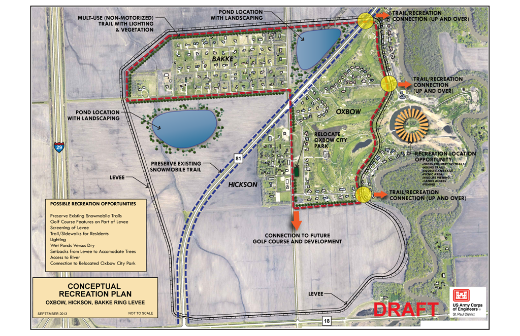
The storm storage areas may be wet or dry and their locations are not final at this time. Your input or concern will help determine their final location to provide the best protection with the least inconvenience.
Recreational Features:
- Walk Path
- Cross Country Trails
- Hiking Trails
- Equestrian Trails
- Picnic Area
- Wildlife Viewing
- Canoe Access
- Fishing
Conceptual Rink Dike Location with Recreational Features

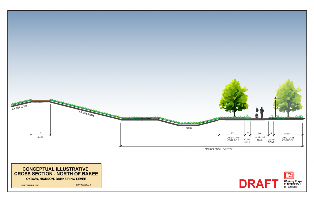
Conceptual Cross Section of Ring Dike North of Bakke

Views: 581
Its a puzzlement to me that the taxpayers of Fargo will spend 70 million dollars on a private country club and a ring dike for a city 12 miles away, when their own city remains unprotected.
Remember – Fargo has to build a temporary a clay dike right in front of city hall when the area gets a heavy rain.
These Oxbow Country Club folks have some pull!
Way to close to our development, I moved out here so I could shoot trap (shotgun) and pistols from my backyard. I do not want a dirt pile, bike path, or trail right behind my property destroying my privacy.
Require a independent study of geologic pressure on our foundations from being located so close to our homes.
Cancel this entire stupid project, if not, buy me out so I can move a long way from Cass County.
Not interested but if you put it up you might not want to put the walking track around the back of Bakke. A number of us shoot bow and arrow, trap, pistol or rifle. And ponds for more mosquito is a really bad idea unless you fill them with fish so the kids can go fishing.
The frosting looks good but underneath it’s still a crap sandwich.
That makes it a frosty crapwich!
Lets stop the growth of Hickson,Oxbow,and Bakke with a ring dike. Now people will have to buy land from our good old boy oh no did I say that? I men’t tax paying land oweners north of the dam..
I look at these so-called “recreational features” they have listed & have to ask, “What out of these listed do we not have access to already?” Also, who will be paying for all the maintenance on these wonderful “new” features?
When my husband & I went to the first one-on-one’s the DA had out in Hickson we questioned why the retention pond was placed where it was. Their answer, which I have recorded, was it needed to go there because of the proximity to the river. Well, the 2nd retention pond they have indicated now is no-where near the river. Obviously, someone (or quite a few) doesn’t know what the hell they’re talking about! If it needs to be by the river, move that thing over to the Oxbow side where the new development is supposed to go.
Also, will the DA be responsible & held liable for maintaining the mosquito infested, West Nile spreading, stinky, potential drowning retention ponds?
For residents of Bakke on south side we will now have a view of a dirt pile instead of the nice open view of the field and the trees in the distance. People purchase their residential homes often times for the view, which we did and find serenity in enjoying this every day. This ring dike proposal ruins every reason for living in this beautiful open space just outside the city. I am NOT in favor of this and encourage other options for consideration!!
Walking trail needs to go on “wet” side of levee….
Looks like drainage ditch is on Northwest side of Bakke…no development for a couple miles in that direction…blizzards winds come from the Northwest…the drainage ditch will be plugged up with a snow drift as tall as the levee and the rest of Bakke snow melts and floods Bakke?????
Fargo dam land includes 25 years of future growth…does the ring diked area include 25 years of Bakke\Hickson\Oxbow growth???
How is all the water that normally drains by the west end going to get north now?
How does the snow melt get out of bakke?
I look at the foot print of this thing and it looks like a couple hundred acres. With a 100″ snow winter, how is 100 acre feet of water going to fit in those 2 acre ponds while the staging area is full?
Or do we tread water for two weeks?