What we do in little, we do in great…
When the FMDA (Fargo Moorhead Diversion Authority) is unjust in the little things the FMDA is unjust also in the big things.
3,691 days have passed since the USACE and local leaders arguably unveiled what was talked about during their “closed door meeting” held 6 days after the first Cass county sales tax vote in Nov 2010.
Reckless FMDA behavior, for over 10 years, would be an understatement monumental proportion. The monitoring, easements and acquisitions should have been item #1 on the FMDA “todo” list…, not an inconvenient term to make legal challenges go away. The FMDA didn’t want upstream interests at the table because they expected everyone to roll over for pennies on the dollar.
Oxbow, ND stands as testament that pennies on the dollar are not enough. Oxbow – touted as a $65 million dollar project morphed into a $132+ million dollar boondoggle with another $30-40 million needed for completion. The entire debacle that transpired with Oxbow was a smokescreen to convince lawmakers that upstream issues had been resolved.
All property owners affected by the FMDA project have just as much right to be made whole as those that benefited at Oxbow.
Call it a belated Christmas gift – there is a local attorney willing to stand up for property owners feeling overwhelmed by the high pressure tactics employed by the FMDA and/or its agents.
The FMDA is not your friend, they DO NOT have your best interests at heart and they always start with the low offer in search of low hanging fruit. If they have lawyers and you have none – you’re out-gunned…
Nobody deserves to be swindled – the following letter is one way to deal with the FMDA.
Don’t sign anything with the FMDA until you’ve spoken to Al Baker – one attorney that seems willing to fight for the little guy.
DOWNLOAD: 2020-12-14 Baker ltr to HDR [ re monitoring ] pdf ↴
| Al Baker Attorney at Law PO Box 1780 Fargo, North Dakota 58107-1780 Phone: 701-630-1846 Email: al@elawpros.com Licensed in North Dakota and Minnesota |
|
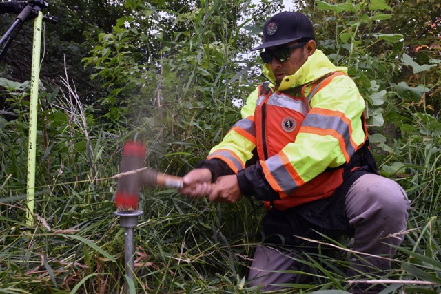
| Stefan Olafson HDR, Inc. 51 N Broadway, Suite 550 Fargo, ND 58102 Re:Dear Mr. Olafson: I have reviewed your December 2, 2020 letter and the attached proposed Environmental Monitoring Easement. I have not discussed the proposed easement with [PROPERTY OWNER] and will do so in the near future. However, there are some issues that I have concerns about, that will need to be resolved before I can fully advise [PROPERTY OWNER] concerning the proposed easement. #1. Your letter states: “They will travel by boat along the Red River and only enter [PROPERTY OWNER] property off the boat, there will be no vehicle traffic and only foot traffic on her property along the river.” Your statement is inconsistent with the proposed easement. The Easement states: “Access to the Easement Property will be by river and street.” The Easement does not restrict access to “foot traffic.” The Easement provides for access “upon, over, in, under, across, and through” and also “ingress and egress in, on, over, across, and through the Easement We both know that your statements are of no value in determining the rights that [PROPERTY OWNER] loses if she agrees to an easement. Your misrepresentation of the terms of the easement is problematic. #2. The easement is granted to “the Cass County Joint Water Resource District” but is for the benefit and use of the “Grantee, its officers, employees, agents, representatives, contractors, and subcontractors, and the United States” with only the Cass County Joint Water Resource District being responsible for any damage caused to [PROPERTY OWNER] as a result of the use of the easement. This is troublesome because it appears that the Cass County Joint Water Resource District was created to obtain the property rights from [PROPERTY OWNER] and others for the benefit of the “Project.” For all intents and purposes the Cass County Joint Water Resource District is like a shell corporation established for the sole purpose of shielding other entities from liability. The easement is for a period of 50 years, there is no reasonable expectation that the Cass County Joint Water Resource District will remain in existence for 50 years. Even if it remains in existence, I do not believe the Cass County Joint Water Resource District will have the resources to answer any damage claims that may arise out of the easements it seeks from [PROPERTY OWNER] and others. To resolve the liability issue, I would suggest two possible alternatives. One the Cass County Joint Water Resource District obtain a bond from an appropriate commercial insurance company or that suitable beneficiaries of the easement such as the City of Fargo, the City of Moorhead and Cass County agree to be responsible and pay for any damage that [PROPERTY OWNER] suffers as a result of the easement. I believe it much more likely that the City of Fargo, the City of Moorhead and Cass County will be in existence for the next 50 years and have the resources to pay any damages that [PROPERTY OWNER] or subsequent owners will incur, than the Cass County Joint Water Resource District will be a credible insurer for [PROPERTY OWNER] potential damages. #3. The easement itself is incomprehensively vague. It allows “performing any other testing, surveys, and analysis” which means that Grantees can do anything they want to the property in the name of environmental testing. The activity could be destructive, as collecting soil samples is allowed without any limitation or restrictions to the area or volume of the sample being removed. The Easement is defectively indefinite because it incorporates terms and conditions contained in “the Adaptive Management Plan” and “revisions thereto.” The AMP is controlled by the beneficiaries of the diversion project and allows terms and conditions of the easement to be fundamentally changed without the consent of [PROPERTY OWNER] . It is impossible for [PROPERTY OWNER] to know and understand what she is agreeing to give up when the Grantee can unilaterally change the terms and conditions of the agreement. #4. The proposed easement creates unreasonable and uncertain potential liabilities for [PROPERTY OWNER]. The easement allows Cass County Joint Water Resource District to place semi-permanent survey monuments on the property to remain in place for 50 years. There are no limits as to the number of the monuments. The monuments are not described. The location of the monuments is not determined. However, [PROPERTY OWNER] is liable for any damage she may cause to the monuments and also liable for any damage anyone entering her property with her permission may cause to the monuments. How can [PROPERTY OWNER] be expected to agree to be liable for damage or replacement of the monuments when she is not provided with any information concerning the number, location of cost of the monuments? #5. While the proposed easement subjects [PROPERTY OWNER] to unlimited liability it limits the liability of the Cass County Joint Water Resource District to the amount paid to [PROPERTY OWNER] for the easement: “Grantor specifically acknowledges the consideration paid represents full and final consideration to Grantor as compensation or damages regarding the Easement Property, any of Grantor’s remaining property, or the Project, and that Grantor is not entitled to any further payments, tax reductions, or damages under any state or federal statute, constitutional provision, rule or regulation, or other legal authority related to this Environmental Monitoring Easement.” Regardless of how much damage the Cass County Joint Water Resource District or its agents cause [PROPERTY OWNER] property under the pretext of environmental monitoring the only responsibility of the Cass County Joint Water Resource District is the illusory promise to repair the damage “as best as practical.” Even the illusory promise is contingent on the existence and resources available to the Cass County Joint Water Resource District during the next 50 years as discussed above. #6. The language used in Paragraph 3 of the proposed easement is overly broad and unclear and could be used to deny [PROPERTY OWNER] for damages caused by diversion project flooding on other parts of her property: “the consideration paid represents full and final consideration to Grantor as compensation or damages regarding the Easement Property, any of Grantor’s remaining property, or the Project.” The easement property and other property owned by [PROPERTY OWNER] are subject to flowage easements caused by diversion project flooding and the proposed Environmental Monitoring Easement must make it clear that it does not include any flowage easement or flooding rights. #7. The limitations of use of the easement property substantially impacts the use and value of all of [PROPERTY OWNER] property. As shown by the previously provided FM Area Diversion, Property Owner: [PROPERTY OWNER] map it is clear that the value of [PROPERTY OWNER] property is substantially enhanced and dependent on the fact that her property includes direct access to the Red River. For the next 50 years [PROPERTY OWNER] use of the easement property will be severely restricted to the point of her losing all access to the river: “Grantor will not use, or permit use of, the Easement Property in any manner that disrupts or interferes with Grantee’s use of the Easement Property, Grantee’s rights and privileges under this Easement, or with the Project. Grantor may plant or farm on the Easement Property at Grantor’s sole risk (subject to the provisions of Section 4 above), but only to the extent Grantor’s use does not disrupt or interfere with Grantee’s use of the Easement Property, Grantee’s rights and privileges under this Easement, or with the Project. Grantor shall not remove of destroy any survey markers placed in accordance with this Environmental Monitoring Easement. Grantor will promptly cease any activities and remove any structures or obstructions that interfere with Grantee’s use of the Easement Property, Grantee’s rights and privileges under this Easement, or with the Project, when directed by Grantee, at Grantor’s sole cost.” The easement admits that it may result in [PROPERTY OWNER] total loss of access and use of the easement property: “The parties specifically agree neither Grantee nor any of its agents or representatives have made any representations or warranties in any way regarding the Project; Grantor’s ability to use the Easement Property following construction of the Project.” #8. I cannot recommend that [PROPERTY OWNER] agree to paragraph 7 of the proposed easement. The Cass County Joint Water Resource District is requesting the easement from [PROPERTY OWNER] It is the Cass County Joint Water Resource District’s obligation to determine the owner of the easement property and not [PROPERTY OWNER] obligation to warrant her ownership. #9. I cannot recommend that [PROPERTY OWNER] agree to paragraph 15. Paragraph 15 is antagonistic to the purpose of paragraph 16. All parts of the proposed easement are critical to the whole and would be relied on by [PROPERTY OWNER] in giving up her valuable property rights. If any part of the contract is invalid, then the whole agreement is invalid. Finally, as written the proposed easement is unconscionable and unenforceable. The proposed easement unfairly protects the Cass County Joint Water Resource District by transferring all risk to [PROPERTY OWNER]. The Cass County Joint Water Resource District obtains all the benefits of the easement by giving it unlimited power to use the easement property in any manner it wants while severely limiting [PROPERTY OWNER] use of the easement property. I look forward to discussing the proposed easement and appropriate compensation for the easement in the near future. Sincerely Al Baker |
|
Views: 1003