
During the November 13, 2017 Governors Task Force meeting at the FargoDome, Terry Williams, USACE, indirectly admitted that the USACE provided false and misleading financial information to decision makers in Washington over Fargo Dam and FM Diversion project.
In essence, what the USACE and Fargo did was embellish the value of the Fargo that existed 2009-2011 and claimed property valuation that Fargo “intends” to acquire (future growth) over the next 50 years as a financial benefit for the project they want today.
Anyone that has applied for a loan knows the implications of providing false and misleading information regarding equity and assets that are used as collateral for a loan. Intentional acts that involves statements that contain materially false information or that conceal information for purposes of misleading another party are generally considered fraud. Shouldn’t the same penalties apply for the proponents that orchestrated the proposed project and inflated BCR (benefit cost ratio)?
Listen to the exchange, questions and cryptic responses:
| November 13, 2017 Governors Task Force Excerpt | |
| Nathan Berseth: Richland County |
…having the, having that undeveloped land taken out the scenario would that not hurt the benefit cost ratio? |
| Terry Williams: USACE |
…we don’t consider that land undeveloped…per se, I think as most people do there are a lot of…umm, homes and businesses and people people living north of where the southern embankment is located right now… |
Really…? A lot of homes and businesses and people north of the southern embankment?
Isn’t it fascinating that concrete berms and rock across the Red River are considered dams, but a concrete and earthen structure towering 6-20 feet above the surrounding farmland is downplayed as an “embankment”?
For starters, when the USACE uses the term “embankment” they really mean a 12 mile wide earthen dam and 3 concrete control structures with operable gates. Then again, the USACE likes to play fast and loose with the facts and obfuscate everything else.
It is almost pathological, how specifically non-specific the USACE can be when asked direct questions.
Pages 227 & 228 of USACE Appendix P (Plan Formulation – Proposal 3) (read more…) offers a very different version of what Terry Williams, USACE, was presenting to the Governors Task Force. Proposal 3 indicates 10 house relocations and a net savings to the project of nearly $142 million in 2011 dollars if the alignment were located north of the Wild Rice and Red River confluence.
The further north the alignment moves, the greater the capacity of the natural flood plain to attenuate flooding in Fargo.
However, the greater concern is that the USACE didn’t consider the land (natural flood plain) undeveloped and exploited the processes and procedures the USACE hierarchy, CWRB (Civil Works Revue Board), OMB (Office of Management and Budget), GAO (Generally Accountability Office) and ultimately the US Congress uses for decision making.
Pages 42 & 43 of USACE Appendix C “Economics” states: (read more…)
“…The area benefited is that area removed from the 100-year floodplain by the project…”
“…In both Tier 1 and Tier 2 most future growth will occur within the 100-year flood plain and, without a flood risk management project, require flood proofing…”
“…There are approximately 20,000 acres within Tiers 1 and 2 and in Fargo available for future development (read more…)…”
Page 259 from Appendix_C_Economics (2011-09-27) – Exhibit N
It’s rather curious that the USACE considers “future development” as though it were “existing infrastructure” for purposes of establishing a benefit cost ratio favorable to the proposed project?
But wait…, it gets better!
| November 13, 2017 Governors Task Force Excerpt | |
| Nathan Berseth: Richland County |
…you said it was, the, southern alignment was decided upon for technical terms, I thought in your EIS it stated…the local authorities chose that, uh, that alignment due to economic benefits |
| Terry Williams: USACE |
…so this, this project is a federal project we have partners…our local sponsors we make decisions together…umm…the sponsors could suggest something and Corps can say no…so these, these decisions were made together…and southern alignment…uhh, as it sits right now is decision we made together looking at…the amount of people impacted the risk associated…umm…with moving the dam north or south…the southern embankment north or south…umm…cost…it wasn’t to (chuckles) raise the benefit cost ratio |
Did you notice the slip up…? Terry William referred to the “dam”, then quickly corrects herself and refers to the dam as the southern embankment.
So at least the USACE admits they have and are colluding with Fargo on the dam and diversion project and they are making decisions together.
Yeah…, about that “alignment”…
| Cited Source | Excerpt from Report |
| FEIS Page 298-299 Appendix O | The ND alignment is a locally preferred alignment and therefore they [Fargo] chose the general location for the inlet. Their reasoning for the location of the inlet being further South than the MN alignment was to accommodate the city of Fargo’s current future plans of development and to protect the city from the Wild Rice River flooding to the South. |
Hmmm…, it wasn’t to raise the benefit cost ratio? Really…???
| Cited Source | Excerpt from Report |
| FEIS Section 3.4.7.3.1 | The initial diversion concept presented in May 2009 was a passive diversion channel without an operable river control structure; this concept was not economically justified with a benefit to cost ratio of approximately 0.65. All of the subsequent diversion concepts included a river control structure that dramatically improved performance with a modest increase in cost. Therefore, no diversion alternatives lacking a control structure were carried forward. |
River Control Structure…, you mean a DAM with operable gates to affect the natural flow of a river that can stage and store water within a reservoir…?
It does beg the question why/how all concepts without a dam were not “economically justified” with a benefit cost ratio of 0.65 but defining the footprint of the proposed project by adding a dam and placing the initial alignment 5 miles south of Davies H.S. to include more than 50 years of future growth into undeveloped farmland and include that future growth into the benefit cost ratio…, somehow, isn’t an attempt to raise the benefit cost ratio?
Wait…, it gets even better!
| November 13, 2017 Governors Task Force Excerpt | |
| Craig Hertsgaard: Farmer Rural Kindred |
…technically when you guys did the BCR calculat, the, the benefit cost ratio calculation, you assumed everything inside the existing diversion channel, the, the proposed diversion channel would be developed, correct? |
| Terry Williams: USACE |
…we assumed that it would be developed with or without the project in place… |
So let’s try and understand the USACE claim they didn’t try and increase the benefit cost ratio, when they refused to conduct an A/B comparison of the area as an un-developed (managed flood plain – restricted development) vs developed (un-managed flood plain – urban sprawl).
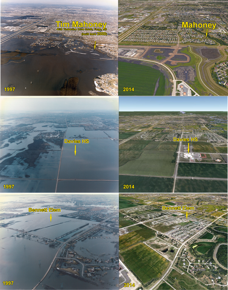
You have floodplain that has flooded during every significant flood. The area where Davies HS is located – flooded in 2009, but Fargo still planted the school smack dab in the middle of the flood plain to drive growth into the flood plain.
Then Fargo’s talking heads bemoan that they need flood protection for the development encroachment areas that they knew were prone to flooding.
Instead of completing internal flood protection to protect the existing city, the FMDA focused on a project that relocates natural flood plain and is obsessed with acquiring land to further the proposed project.
Generally speaking, the FMDA (Fargo Moorhead Diversion Authority) is trying the cheat landowners with low buyout/acquisition offers and threatens eminent domain if the landowner doesn’t accept…, and they are colluding with the USACE to achieve that end.
The FMDA offers around $5,000 per acre for undeveloped farmland, but the USACE calculated undeveloped farmland as a benefit to the project at $35,000 per acre (future residential land) and $62,500 per acre (future commercial land). Boosting the benefit cost ratio in this manner means the FMDA cannot scale back the proposed project to only protect the existing city of Fargo, because the project will not qualify for any federal money.
So when the USACE overstated undeveloped farmland by $30k-$42 per acre to claim greater benefits…, how is that NOT a very deceptive way to raise the benefit cost ratio to an acceptable level to qualify for federal funding.
What is the minimum acceptable benefit cost ratio?
| November 13, 2017 Governors Task Force Excerpt | |
| Terry Williams: USACE |
…yeah, in order to…, for the federal government to make an investment in a project it’s gotta be above 1.0 [BCR]… |
Very interesting…
Now we come full circle on the benefit cost ratio. During testimony exchanged in May 2009 between Byron L. Dorgan (ND – US Senator & Congressman) and Colonel Christensen (USACE) (read more…) a special hearing was conducted before a subcommittee of the US Senate – Appropriations Committee, wherein, Colonel Christensen indicated the benefit cost ratio was 0.65 for 100 year flood plus 4 feet for the existing city.
The USACE and FMDA knew the benefit cost ratio wasn’t good enough and then conspired to portray undeveloped farmland at greater value to push the benefit cost ratio higher.
It certainly explains this excerpt of GAO (General Accountability Office) testimony from 2006:
| “…planning studies conducted by the Corps were fraught with errors, mistakes, and miscalculations, and used invalid assumptions… …the Corps’ studies understated costs and overstated benefits, and therefore did not provide a reasonable basis for decision-making….” |
Y’know, there was once a time that the USACE had a level integrity that people admired.
Today, it appears the USACE have become desperate salesman peddling development projects for the next paycheck…
Views: 1464
Minnesota DNR was not able to verify the flood damage figure that the Army Corps used to concoct the cost benefit ratio.
I wonder how Terry looks in orange?!