What do the Fargo Diversion Authority and Juan Ponce de León have in common…?
“Magic Water”
For Ponce de León, it was the legendary “fountain of youth”, for Fargo it is the magical flood waters that somehow disappear in little over 3 miles between the confluence of the Wild Rice – Red Rivers and the Lower Wild Rice and Red River cemetery (LWRRRC).
Located roughly 1500 feet south of the Cass 16 and Hwy 81 intersection…, it is…, the proverbial “fountain of youth” for Fargo’s development plan south of Davies H.S. and other areas south of 52nd ave.
Here are the known facts.
• FEMA is the single federal agency that gives final determination on flood risk
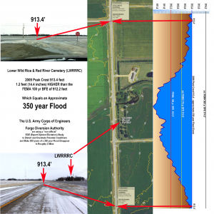
zones relating to flood insurance ratings.• Photographs and LIDAR elevations indicate a peak crest a the LWRRRC
being 913.4 feet.• Historical flood CFS discharge records and the Feb 2013 USACE “White Paper””
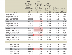
indicate Oxbow, further upstream, exceeded the FEMA 500 year flood level in 2009.• Fargo’s Diversion Project Management Firm, CH2M HILL independently confirmed
the 2009 peak elevation at the LWRRRC being 913.4 feet.• Based on FEMA’s most recent study, water exceeded the 100 year flood BFE
by 1.2 feet (14.4 inches). Upon further analysis, the 2009 peak flood at the LWRRRC
was approximately a 350 year flood event.
So how does a historical 350 year flood magically disappear in approximately 3 miles only to emerge as a downgraded 50 year flood?
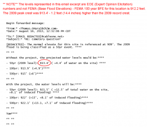
This is done with the legendary EOE (Expert Opinion Elicitation) study.
Fargo Diversion Authority and the U.S. Army Corps of Engineers (USACE) devised a way to mislead the public and lawmakers into believing the 2009 peak was only a 50 year flood.
The fundamental question is “WHY” was the EOE done?
In short the EOE, which is a non-official scientific theory postulated by a handful of handpicked scientists, to explore a worst case flood scenario with criteria prejudiced toward the proposed FMM project. The USACE needed higher numbers in order to overstate potential flood conditions to hide downstream impacts created by the project and to effectively increase the projects cost benefit ratio. So on September 28-29, 2009 the USACE assembled participants in St Paul to conduct the EOE study, which included six experts chosen by the St. Paul District to serve on the expert panel, five invited observers with specialized knowledge, and staff of the USACE St. Paul District.
Rather odd that in just two days, scientists handpicked by the USACE can thoroughly evaluate the Red River Valley natural flood plains, when FEMA has be determining the existing flood plains for decades. Even more suspect is the lack of any mention of encroachment impacts that have displaced in excess of 25 inches of more flood water from those natural flood plains directly affecting the Fargo, ND river gage.
How can any intelligent person accept that the EOE science is sound when a future unproven condition does not factor in a known historical proven condition exacerbated by natural flood plain encroachment?
Let’s move onto the cost benefit ratio.
| Excerpt: Page 41 USACE – September 2011 FEIS
3.4.7.3.1 The initial diversion concept presented in May 2009 was a passive diversion channel without an operable river control structure; this concept was not economically justified with a benefit to cost ratio of approximately 0.65. All of the subsequent diversion concepts included a river control structure that dramatically improved performance with a modest increase in cost. Therefore, no diversion alternatives lacking a control structure were carried forward. |
Ironically, there wasn’t an EOE included in the original Scoping Document or Alternatives Screening Document. However, when the projects cost benefit ratio ( .65 ) failed to meet the general threshold needed for congressional consideration, the USACE and Fargo Diversion Authority scrambled to find a way overstate future conditions and achieve a higher cost benefit ratio to shill the project into the WRDA bill in Washington, DC. Hence the pursuit of an EOE study to try and justify the project on paper.
| History of the “Moving” FMM Cost Benefit Ratio | |
|---|---|
| May 2009 Initial Cost Benefit Ratio | .65 |
| Dec 2009 PRE EOE Cost Benefit Ratio | .95 |
| May 2010 POST EOE Cost Benefit Ratio | 2.26 |
| Jun 2013 VE13A Alignment Cost Benefit Ratio | 1.5 |
Had the EOE not been done, the project would had died because the initial cost benefit ratio was insufficient.
Rather interesting that the USACE and Fargo Diversion Authority need the project located as far south as possible, with a Class 1 High Hazard dam, pumped up with non-official EOE hydrology to maintain any chance of federal funding. The EOE study, in its entirety, is an ipse dixit.

Just food for thought…, what gives the USACE or Fargo Diversion Authority the right to over-reach and edict non-official EOE numbers, that places more areas of Fargo and the Red River Valley under the threat of flood insurance requirements, as the new benchmark from this point forward?
So let’s get back to the LWRRRC. It is a fixed point upstream of Fargo where Fargo’s Diversion Project Management Firm, CH2M HILL did a rare thing and shared requested information, which can be independently vetted with pictures and LIDAR elevations.
The historic crest of 2009 reached 913.4 feet, which exceeded the FEMA 100 year event by 14.4 inches, making it a 350 year flood event.
Ironically, the USACE “White Paper”, released February 2013, indicated that Oxbow, ND experienced a 350+ year flood in 2009 by exceeding FEMA’s 500 year flood discharge of 21,818 CFS.

So how does 300 years of a 350 year flood magically disappear…?
Sadly, the secret to Fargo’s Magic Water isn’t that mysterious.
In a nutshell –
“Just add water…, mix in a lil’ hype and spook people with rising flood insurance.”
Ponce de León would be proud! Fargo found a way to make their own “Magic Water”
Views: 243
What the Corps does is, take the contrived EOE flood elevation numbers and make them the “existing flood numbers”. This has two effects. It inflates the damages assessment and the cost benefit ratio. It then downplays the real flood level that is put on the upstream areas. They say, well “we are only putting two feet of water over existing conditions”. When the “existing conditions” (EOE numbers) never have occurred and would take twice as much water as has occurred in the last 4 biggest floods in the last 131 years to match the EOE flood numbers.
Numbers are manipulated all the time in medical studies. You can get the desired end results if you play it right.
But here’s the deal.
Drive around in rural Minnesota or north Dakota South of Fargo. Fields and sloughs are being drained to create more farm land. We need it to feed hungry people but does it all need to be drained at the same time?
My God. You can’t work all the fields at the same time nor can you plant them all. Nature created holding patterns that are being significantly changed.
Fargo flood problems might not be as bad if this was not done. Hold the water back a little bit Mr Farmer!
If rural communities are going to sue them let’s go after every one.
Develop some sort of pattern to hold the water back like a grid system.
Fargo is a major hub. They need to do what it will take to fix it. The dam is the best solution if no one else is going to dig in.
I live on the Red south of Fargo. 2009 was much worse. Water came in much quicker and was deeper Between 96 and 09 allot of farm drainage occurred.
Let’s make a bunch more money for the starving attorneys by suing every one.
Curt “DocFizx” Ficenec,
Just because medical studies manipulate data – doesn’t make it morally acceptable. The data that Fargo and the Corps has been intentionally manipulating is being done in an attempt to do an immoral thing. Taking flood prone land and relocate that water to foster tier 1 and tier 2 Fargo development under the guise of a flood control project to obtain local, state and federal funding support, which is, in itself, tantamount to fraud.
Fargo and Cass brazenly lies when they claim the diversion provides vital flood protection for the region. It ONLY provides benefit to Fargo.
I agree, there are considerable areas that have been drained, however, the massive grid-work that you suggest already exists in the form of roads and bridge crossing which impedes the natural flow of water off farmland. The additional drained land, in many cases, is being done to offset the water already being held on the the farmland by unnatural means.
This is also why distributed retention is such an important component that the Fargo Diversion Authority has refused to consider in the entire process…, up until a few recent headline public relations murmurings.
Whether Fargo is a major hub or not should not garner preferential treatment for urban over ag-land. Imperial Fargo, Imperial Cass has “no business” trying to dictate how areas outside Fargo’s jurisdictional boundaries should exist. Why is Fargo being reckless and pursing a dam and diversion along with the $70+ million OHB project before completing internal protection for the city that currently exists. Mayor Dennis Walaker claimed that it will take them 4 years to complete internal projects, yet they’ve already had 5 years since 2009. Nonsense! Fargo is dragging their feet on completing the very protection they lament having to build every time they spin flood crest forecasts in their favor.
Fargo has chosen to grow in a manner that is creating the bulk of their flooding issues. Fargo widely proclaimed that they exceeded flood stage every year since 1993, until they didn’t. Ironically, the development of Rose Creek and adjacent areas has more to do with exceeding flood stage by reducing vital flood plain capacity.
Since 1969, Fargo has encroached and reduced enough flood plain capacity to create a river crest 25.2 inches higher at the gage when comparing the 1969 peak flow to 2009. That isn’t farmers draining land…, that is Fargo building where the water naturally pools and relocating that water onto areas where it creates a greater threat and more damage.
In 2004-2005, the FMUS study identified up to 19.2 inches of benefit to Fargo with distributed retention and the Fargo Diversion Authority chose to terminate the study in Jan 2013, largely, because it did not compliment their postulation that their desired dam and diversion is the “only solution” to Fargo flooding.
There is a study published in the Journal of Hydrology 511 (2014) 474-483 regarding the impact of subsurface drainage on stream flows in the Red River of the North basin. Which clearly states that draintiling would likely increase the magnitude of smaller peak flows while decreasing the magnitude of larger peak flows.
Here is a link to the article:
Journal of Hydrology 511 (2014) 474-483
What you have outlined is a fundamental reason why distributed retention should be pursued as vehemently, if not more, than the current proposal for the Fargo Dam and FM Diversion.
Yes, the lawyers are making bank on this project. However, people have a right to defend themselves against unnecessary aggressive actions of cities like Fargo and co-opted governments like Cass county.
Fargo could have easily saved the city millions in legal fees by sitting down and working towards a compromise with people they have arbitrarily and unnecessarily chosen to impact.