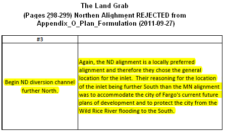
The recent “rejection” of a viable, more robust, flood protection plan which is truly a Fargo First solution underscores the Imperial Fargo – Imperial Cass mentality.
What the Forum, Fargo Diversion Authority and the USACE is withholding from the public is that nearly 80,000 acre feet of capacity already exists in the natural flood plain that Fargo wants to develop. Even more shocking is that Fargo’s encroachment south of I-94 caused the 2009 flood crest…, not mother nature running amok with wetter conditions.
The number to focus on is an additional 80,000 acre feet of water staging/storage. Which could easily be done by adding 1 foot of capacity to the existing natural flood plain and restrict development between where Fargo currently exists and the communities of Bakke, Hickson, Oxbow, ND.
The Fargo Diversion Authority wants to maintain it’s lie that this isn’t a “land grab”.
Then it begs the question why are they bent on relocating approx 80,000 acre feet of water to develop land that is a natural flood plain.
What is so scary about providing Fargo with less risk and more robust protection by preserving the natural flood plain.
Oh yeah…, future growth… (massive eyeroll)
| F-M diversion officials reject plan offered by project opponents By: Kyle Potter, INFORUM FARGO – Fargo-Moorhead diversion officials have brushed aside an alternate flood control proposal from project opponents south of Fargo. The plan, unveiled by the MinDak Upstream Coalition and the Richland-Wilkin County Joint Powers Authority last month, calls for shifting the flood control project north and replacing the so-called “staging area” with a system to distribute water into reservoirs. |
There is nothing “so-called” about the staging and storage area designed to be a temporary reservoir immediately upstream of the proposed 12.5+ mile wide Class 1 High Hazard dam stretching from Sabin, MN to Horace, ND.
| Kyle Potter, INFORUM: Group members say it would provide the same level of flood protection while eliminating the need for ring dikes around several communities. U.S. Army Corps of Engineers officials and members of the Diversion Authority acknowledged the alternate proposal Thursday, but said they’re sticking with their plan. “Our plan is our plan. Our alignment is our alignment,” corps project manager Terry Williams said. |
Interesting response from Terry Williams, U.S. Army Corps of Engineers.
Listen to Terry Williams, USACE, clip:
Here is the Music Player. You need to installl flash player to show this cool thing!
Alternate Terry Williams Download MP3 (139 kb)
Dismissed Proposal 3 [pdf] ← (read in-depth two page “study”)
Despite various suggestions to the Fargo Diversion Authority from John Hoeven, Heidi Heitkamp, Kevin Kramer, Collin Peterson, Amy Klobochar and Al Franken to sit down and work things out with upstream interests that have been denied a seat at the table and work things out, the arro-ignorant response to recite “Our plan is our plan. Our alignment is our alignment,”…
It’s almost, as if, proponents are behaving like Gollum (aka: Schmiegel) from Lord of the Rings, reciting the infamous phrase “my precious” in regards to the proposed Fargo Dam and FM Diversion project.
Just stop and think about this…, the United States is $17.3+ TRILLION in debt and Terry Williams (USACE) has the temerity to insist that a $2+ billion Fargo ONLY project takes precedence over a cost effective viable solution to Fargo flood protection which could also include basin-wide benefits.
Listen to this clip from US Congressman Rep. Collin Peterson, D-Minn:
Here is the Music Player. You need to installl flash player to show this cool thing!
Alternate Collin Petersen Download MP3 (2mb)
| Kyle Potter, INFORUM: Nathan Berseth, a spokesman for the MinDak Upstream Coalition, said in an interview he was disappointed his group’s proposal was declared “dead on arrival” without a third-party study. He said they had received little to no response from diversion officials. “We haven’t heard anything, which is their M.O.,” Berseth said. |
From the very outset of this proposed project has ignored all sensible alternatives and any combined alternative that includes retention as a way to reduce water traveling towards Fargo.
| Kyle Potter, INFORUM: During Thursday’s meeting, Williams said the corps discussed their position on the alternate proposal when Corps Brig. Gen. Duke DeLuca visited Fargo earlier this month and felt that was sufficient response. |
It’s easy to believe the USACE fabricated lie/opinion, when the listener chooses to ignore any metrics of verifying the truth. Corps Brig. Gen. Duke DeLuca is paid to rubber stamp whatever his underlings push up the chain of communication.
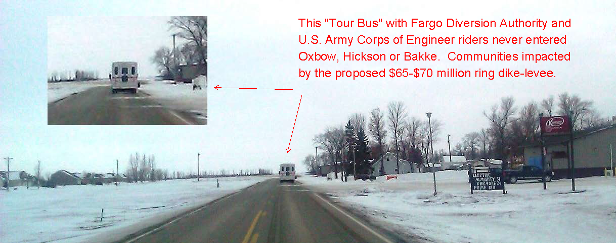
During Deluca’s visit, a photo-op tour “just for show” took riders along Cass 25 but never entered Oxbow, Hickson or Bakke. One can only speculate that sympathy was given to Oxbow for their 2009 flood fight and pats on the backs all around for the $65-$70 million for the new golf course, clubhouse and ring dike.

Ironically, Hickson and Bakke did not flood in 2009…, was that brought to Corps Brig. Gen. Duke DeLuca’s attention?
| Kyle Potter, INFORUM: Diversion supporters and opponents agree the coalition’s proposal was largely borrowed from an option the corps once studied only to reject it. The Diversion Authority is moving ahead with plans for a storage area south of Fargo, where water would collect during heavy floods to be fed into a 36-mile channel around the metro area. The two sides disagree with the reasons behind that rejection. |
Here are the facts.
Cited Source: U.S. Army Corps of Engineers documentation:
|
Appendix O: Plan Formulation: Page O-89
8.5.3.4.1 Alignment There is a strong desire from the non-federal sponsors and the public to have the diversion plan constructed in North Dakota. A North Dakota alignment would be considered highly acceptable to the non-federal sponsors. The Minnesota alignment is also acceptable, as the non-federal sponsors and the public have indicated that doing nothing is not an option; however they generally prefer the North Dakota alignment and officially requested the North Dakota alignment as the locally preferred plan. |
Non-Federal Sponsors = Fargo (major) Moorhead (minor)
|
SDEIS: Page 39: Alternatives Page 7
1.5.2.2 Fargo Southside Flood Control Project, City of Fargo, North Dakota. After the 1997 flood, the city of Fargo and the Southeast Cass County Water Resource District conducted planning for a flood risk management project to protect developments in the area south of Fargo and north and west of the Wild Rice River up to 4 miles south of its confluence with the Red River. Several alternatives were explored, including combinations of levees, diversion channels, channel modifications and flood storage. The Southside study was discontinued when it was overcome by the Fargo-Moorhead Metro feasibility study (the subject of this report). The Southside study will resume only if no federal project is recommended to address flooding in the area south of Fargo. |
The fundamental problem created by moving the inlet so far south is that it creates the very impacts that Fargo claims it needs protection against. The Fargo Diversion Authority knows this…, ignores this and chooses to leave the city at risk in a dangerous gamble for a dam and diversion that is decades away from providing any benefit to Fargo residents in the short term.
| Kyle Potter, INFORUM: Diversion officials say the alternate proposal would affect an estimated 200 more people than their current plan and add an extra $53 million to the cost of the $1.8 billion project. Berseth argued their plan would, in fact, be cheaper. He countered – and a lawsuit in federal court alleges – that diversion officials selected their current plan in order to protect floodplains south of the metro for future development. |
Let’s see…, 200 more people affected, yet those people are impacted already as a result of Fargo’s encroachment into the natural flood plain.
Also, it’s amazing that the “alleged” in depth study of Proposal 3 north of the Wild Rice – Red River confluence cited only 10 homes.← (read two page “study”)
As for costing $53 million more? Absolute nonsense! Proposal 3 cited a $142 million saving by removing the Wild Rice dam control structure.
In addition to Proposal 3 – $30-$50 million would be saved by not having to raise I-29 and Exit 50. Throw in the savings of not raising Hwy 75, railroads and ring-dike-levees around Comstock and Wolverton, MN and potential ring-dike-levee and diversion around Christine, ND and the savings to project keep increasing.
The current project is bleeding money at a staggering pace. Inflationary costs and mission creep has the potential to drive the feigned $1.8 billion cost to over $3 billion.
So if Fargo is truly concerned about its residents…, why are they dragging their feet in completing internal protection?
Fargo First! Complete internal flood protection and detain water heading towards Fargo.
Views: 301


“Our Plan is our Plan”… and the summarily dismissed other option occurs after months of “why don’t the opposition present a plan any plan”…
Another completely perplexing concern is Fargos water supply problem. Increasing White Rock Dams capacity, and other staging upstream increases Fargos water supply.
The last legistlature approved studying flood projects and the water supply problem for Fargo:
III. SB 2233 Amendments and Conference Committee Action.
SB 2233 was further amended and reported out of Conference Committee (6-0) on April 24. The bill
passed the Senate on April 25 (42-2) and the House on April 26 (90-3).
The first part of the bill provides a declaration of water policy and goals and objectives, and establishes an
Infrastructure Revolving Loan Fund within the Resources Trust Fund. The second half of the bill
restructures the funding model for the Western Area Water Supply project.
“The
committee shall work collaboratively with the state water commission to develop policies to further
define the state role in major flood control projects and in the prioritization of water projects.
During the 2013 – 14 interim, the committee shall review water supply routes and alternatives for
the Red River valley water supply project.”
Yet a solutions that solves both at once is rejected without any consideration….
Absolutely criminal if you ask me.
I many times have listened to jeff volk knock retention plans that were too far away from the river. He went on to say that you would have to double and triple acre feet when you move the retention up stream to get the same affect of storage near the target area.
Now the DA wants to get rid of 80,000 acre feet where you would think the engineers would deem it most valuable (see jeff volk above). The real goofy thing is, Fargo wants to build homes there, in the bottom of the bowl. when will they stop the insanity?
Build homes next to a river that floods? and try to get a broke federal government to pay for this boondoggle????
Basin wide plans is where its at, Fargo. Slow the water so it can move into the river in a managed way and protect everyone.