A coalition of concerned citizens, both directly and
indirectly affected by the proposed Fargo Dam
PO Box 35 ▪ Christine, ND 58015
Report to Budget Section
North Dakota Legislature
September 24, 2014
Chairman Pollert, committee members, thank you for the opportunity to update your committee on our situation regarding the proposed FM Diversion project. My name is Craig Hertsgaard. I am a farmer at rural Kindred, and here on behalf of the MnDak Upstream Coalition. With me today is Dave Morken, President of the Upstream Coalition and Rae Ann Kelsch, our lobbyist. Our group is made up of those who will be adversely affected primarily by the reservoir, or staging area that will cover approximately 50,000 acres upstream of dams on the Red and Wild Rice Rivers. There is another organization, the Richland-Wilkin Joint Powers Authority, which is a group of more than thirty governmental entities that includes counties, townships and school districts among others. More recently, a third group has been formed called the Upstream Cemetery Authority. That is a group of 16 cemetery associations who believe their graveyards will be inundated by the project.
I am going to divide my presentation into two parts. First, I would like to cover the major conflicts between the rural area upstream and the Diversion Authority. And secondly, I will address alternatives that protect Fargo from flooding without shifting the damage to us.

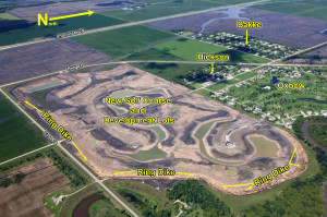
Critical impacts to those of us upstream are farmland flooding, damage to roads and infrastructure, flooding of cemeteries, and relocation of residences and farmsteads. In addition, residents of Hickson and Bakke are extremely concerned about the ongoing construction on the massive ring dike around their communities.

Several of our members have taken part in the ag impacts group sponsored by the Diversion Authority. The Army Corps impact statement outlines easements as mitigation for impacts. The Diversion Authority has been exploring a supplemental insurance plan to compensate farmers when the project is in operation, since traditional crop insurance won’t cover damage caused by the project. There are two concerns with this current path. The self insurance policy is meant to mimic traditional crop insurance at 65% coverage and prevented planting coverage. The most likely impact is that planting would be delayed. The worst case is that no planting can occur. Farmers would suffer a loss of up to 35% with no compensation at all. Prevented planting coverage is the same. It also covers a small portion of the loss.Flowage easements would be expected to make up for the shortfalls. Flowage easements are a onetime payment, with no tie to how much damage would be caused in perpetuity. The Corps EIS indicates the easements would be 25% of appraised land values. Remember in today’s dollars, it costs about $600 to grow an acre of corn and about $1000 to produce an acre of sugar beets. That’s without consideration for what might be the case 20 or 50 years from now. This project is forever. Our members do not feel that the true cost to ag producers is being given serious consideration.
A related issue is how many acres will be compensated for damage. Army Corps maps indicate the staging area will cover 50,000 acres. They say 32,000 acres will be mitigated. The 18,000 acre discrepancy is where the water will be less than one foot deep. Compensation for that damage is not be automatically considered. Damage will be determined by a takings analysis conducted by the Army Corps. We have asked for the results of that analysis, but have been told we cannot see it because of attorney client privilege. We believe that means farmers whose land is covered by 10 inches of water instead of twelve will have to sue recover damages. I’m pretty sure the crop will be equally dead or unplanted. This immediately puts us in an adversarial position with attorneys for the Army Corps and Diversion Authority, and on the losing end.
A major concern of residents, schools, emergency personnel and townships is damage to our infrastructure. Diversion Authority members tell us they will flood and drain 50,000acres in nine days. That is over 75 sections that are supposed to be flooded through the current culvert system, and drain again without overtopping gravel and minimum maintenance roads and without causing damage. If any of you have experience with roads and floods in our area, you will know that is not possible. We have asked Army Corps engineers as recently as last month how they will deal with this, and they say they have no answers.
A very serious question is what will happen to the cemeteries in the staging area. The best estimate of the Cemetery Authority is that there will be more than 3000 graves flooded. One of the North Dakota cemeteries will have up to 14 feet of water on it when the dam is in operation. Many of the cemeteries cannot be ring diked because of the depth of the water or proximity to land features. Burials would likely have to be restricted during certain times of the year because of hydraulic pressure on recent interments. Army Corps personnel recently visited cemeteries that will be impacted by the project. Family members of those buried met with Corps members at most of the cemeteries. Most of the visits were extremely adversarial. This issue will not go away.

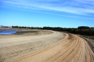
The final issue I will bring up is the Oxbow ring dike. Most of you know that construction on the southeast and south sides of the dike have run at a fevered pitch for much of the summer. Residents of Bakke and Hickson are strongly opposed to this dike, because they feel it will reduce the values of their homes, and place them at risk for a catastrophic failure when they are surrounded with water by the proposed dam. And although promised, they had no say in whether this dike will be built. It’s hard to understand why 65 million dollars is being spent on a ring dike for a community where five homes need flood insurance, when the city of Fargo remains without adequate dikes.

To my knowledge, since the idea of a diversion was developed, there has never been a serious discussion with any upstream group about project design changes that would lessen the negative impact of the plan. Every discussion has been about mitigation for a plan the Diversion Authority hired the Army Corps to develop. Late last week, the Diversion Authority asked MnDak and the Joint Powers Authority to nominate a representative to sit on their 9 member board. The position would be excluded from legal and financial discussions. This is an interesting development to say the least. This committee should know the background for the proposal.
The Richland Wilkin Joint Powers Authority filed suit against the Army Corps about a year ago. The suit alleges that the Corps report did not adequately consider federal flood plain rules and Minnesota laws with regard to project design. The Diversion Authority joined the lawsuit on behalf of the Corps. In February, the Minnesota DNR sent a letter to the Diversion Authority suggesting that they should not begin construction on the ring dike around Hickson, Oxbow and Bakke until their state review of the project was complete. The Diversion Authority and DNR have been corresponding on that issue. As our lawsuit has developed, the DNR has apparently become concerned about arguments over Minnesota’s right to govern their waterways and land use. The Diversion Authority argues the WRDA bill pre-empts state law. The Minnesota DNR filed a brief in the lawsuit defending their sovereignty on those issues. The discussion has led to Minnesota Governor Mark Dayton visiting the area, and ultimately sending a request to the White House to halt the project, and a letter to the Diversion Authority requesting a larger voice for Minnesota. Dayton requested that Minnesota legislators from Clay and Wilkin counties decide what representation is appropriate. We don’t know how we will respond to the invitation until we talk to folks on the Minnesota side of the river. When you read Dayton’s letter to the White House, it makes you take a step back to consider its effects.
We don’t oppose flood control for Fargo, just the opposite. Agriculture is the economic engine that drives the Red River Valley, but Fargo, West Fargo, and Moorhead are the transmission. They are as much a part of our lives and businesses as the communities where we live. There are other options that can protect the city and economy of the region.
Since the last legislative session, significant study results and funding opportunities have developed that can give the valley the protection it needs. The Red River Basin Commission completed an updated Long Term Flood Solutions study partially funded by the Diversion Authority that reinforces the idea that distributed water storage on streams and tributaries can reduce the flow of the Red River at Fargo by 20%. Fargo is finally pursuing construction of dikes and levees through town to a level of 43 feet. Moorhead is protected to 44 feet. The record flood of 2009 was 40.8 feet. Results of the Red River Basin Study indicate the Red would not exceed 40 feet even at the inflated 100 year flood level Army Corps estimates used in their diversion study, if distributed storage is developed on a valley wide basis.
But the biggest elephant in the room on flood protection is money. This is a federal project designed to have federal participation, but the federal government has no money. The continuing budget resolution funding the government in Washington has had a ban on new project construction funding for the last four years, with no end in sight. If you read the letter to the White House from the Minnesota governor, you’ll see he is requesting that no money or support be given to the diversion project, at least until the DNR is done with their study.
The basin wide approach to flood control is in a much better position to attract financing. The Farm Bill allocated $50 million dollars to retention projects this past summer, with a chance to get another $200 million. Both Minnesota and North Dakota have programs to provide funding for distributed storage. The Diversion Authority has offered $25 million of their own money for those projects.
It’s good news that Fargo has begun dike construction in town. In 2012 they estimated the cost of a dike system to be $247 million. The last legislature appropriated $175 million to help with the project. These two flood control features could go a long way for flood safety for Fargo while a more realistic diversion plan is developed.
As for our situation, I’m disappointed to report that there has been no progress resolving our grievances with the Diversion Authority. I have listed a number of the issues and their underlying causes today. This despite the fact that the last legislature urged them to address the concerns of the upstream residents. Governor Dalrymple asked the DA to resolve the issues with us. Senator Hoeven asked them to work out their differences with us. Senator Heitkamp asked them to address our concerns. Congressman Cramer did the same. Minnesota Congressman Peterson asked them to reconsider their design. And now, Minnesota Governor Dayton has objected to the lack of concern for his side of the river and their state laws and their DNR has joined our lawsuit against them.
As it stands, there will be no federal money for this project. The future of flood control in the Red River Valley must be a joint effort between Minnesota and North Dakota to reduce river flows, build up dikes and levees, and develop efficient diversions and bypasses to protect existing infrastructure that is at risk. Our home in the Red River Valley is a wonderful place, with small growing communities outside the natural floodplain that enrich the Fargo Moorhead metro area with talented and motivated employees to meet our vibrant economy. We hope we can all grow a future together that will make our kids believe it is the best place on earth to live.
Read Opposing Testimony: Darrell Vanyo, chairman, Fargo Diversion Authority
Views: 248
